Complete Guide to the Manali Leh Ladakh Road Trip: Everything You Need to Know Now
Have you been dreaming about a trip that blends high-altitude mountain passes, serene villages, and a distinct cultural tapestry? If so, the Manali Leh Ladakh road trip might be next on your list. People often talk about “going off the beaten track,” but what if you could experience a route where towering peaks, winding roads, and vibrant local lifestyles come together to offer something new at every turn?
In this guide, I’ll walk you through every practical detail of the journey. We’ll cover everything from ideal travel times to the must-try food along the route. I won’t dive into ancient histories, because that’s not our focus. Instead, I want you to understand the current travel scenario. By the end, you’ll be armed with all the knowledge you need to make the most of your trip.
Table of Contents
Why Choose the Manali Leh Ladakh Road Trip?
Why not simply fly to Leh and call it a day? You could do that, but you’d miss out on scenic valleys, quiet local stops, and the gradual transition from one landscape to another. The journey itself is a highlight—like a never-ending gallery of natural wonders.
Are you interested in seeing how the vegetation changes as you drive higher? Do you like the idea of pausing at tiny hamlets for a quick chat with locals? The Manali–Leh road route is more than a commute; it’s a series of experiences tied together by thrilling highways and the curiosity to see what’s waiting around the next bend.
Key Highlights
- Altitude Variety: You begin at around 2,000 meters in Manali and eventually cross passes over 5,000 meters.
- Cultural Mix: You’ll meet people from different ethnic backgrounds—some belonging to Himachal Pradesh, others to Ladakh.
- Photography Galore: Each segment of the drive is photogenic, whether it’s the lush Kullu Valley or the arid high-altitude plains of Ladakh.
Best Time to Travel
Are you wondering whether it’s possible to drive this route in winter? Let’s clear that up right away. This route is typically open only between late May or early June until around mid-October. Beyond that, heavy snowfall and ice make it dangerous or outright impassable.
- June to July:
- Pros: Spring blossoms still linger around Manali, and the higher passes have just opened. You’ll see patches of snow at higher altitudes.
- Cons: Rohtang Pass can get crowded. Some sections may still be slushy due to melting snow.
- August to Mid-September:
- Pros: This is often considered a prime window. The weather is relatively stable, with fewer road closures.
- Cons: Occasional rain in the lower sections. Also, this period is popular, so you might not have the route to yourself.
- Mid-September to Early October:
- Pros: Crisp weather, clearer skies, and fewer tourists. Ideal for photography enthusiasts who love autumn shades.
- Cons: Nights get cold. Higher passes may see early snowfall.
If you want moderate temperatures, fewer uncertainties, and better road conditions, aim for August or early September. For more precise daily weather updates, consider checking the official India Meteorological Department (IMD) website before planning.
Preparing for the Journey
Preparation can shape your trip experience. How do you ensure a smooth drive on such a high-altitude route? Let’s look at the essentials.
Vehicle Check
- Engine Health: Make sure your vehicle—car, SUV, or motorcycle—is in good mechanical condition.
- Tyres: Tread depth matters; you might deal with muddy, rocky, or uneven roads.
- Fluids and Spares: Carry extra engine oil, coolant, and a basic toolkit.
Physical and Mental Readiness
Have you thought about altitude sickness? Acclimatization is often overlooked, and if you’re not careful, you might experience headaches or fatigue.
- Stay Hydrated: Water is your best friend at high altitudes.
- Gradual Ascent: If possible, spend a day or two in Manali to adjust before heading higher.
- Carry Basic Medication: Consult a doctor for medication related to altitude sickness prevention or relief.
Must-Haves
- Layers of Clothing: Temperatures can shift dramatically from day to night.
- Snacks and Dry Food: Roadside eateries aren’t always around the next corner.
- Flashlight or Headlamp: Night travel is not advised, but keep a light handy in case you’re delayed.
- Emergency Contact List: Save local helpline numbers, including the Border Roads Organization (BRO) updates line.
Permits and Paperwork
Ever wondered if you need special permission for crossing these passes? Indian nationals typically do not need a permit for the Manali–Leh route itself. However, if you plan side trips to Pangong Tso, Tso Moriri, or Nubra Valley from Leh, you might need an Inner Line Permit (ILP).
- Where to Get the ILP: You can obtain it from the Ladakh Tourism Office in Leh or apply online (the portal may change, so check official websites for current links).
- Documents Required: Valid ID proof (passport, Aadhar card, voter ID, etc.). If you’re a foreign national, you might need additional documentation, so do confirm with local authorities.
Keep a few photocopies of your ID in case they’re required at checkpoints. The local authorities have been streamlining these processes, so it should not be a tedious task.
Detailed Route Breakdown
Let’s divide the Manali–Leh drive into three primary travel days. Some prefer doing it in two days with a single night halt, but that is physically demanding and offers little time for acclimatization.
Day 1: Manali to Jispa
- Distance: ~140 km
- Elevation Gain: ~2,000m in Manali to ~3,200m in Jispa
- Approx. Travel Time: 6-8 hours
Highlights
- Rohtang Pass (3,978m): Your first major pass. Expect scenic views, possible early morning mist, and crowds during peak season.
- Gramphu and Kokhsar: After descending Rohtang, you’ll come across Gramphu. Kokhsar is a short drive away and is often a preferred spot for a meal break.
- Sissu: A picturesque village with a waterfall that’s visible from the main road. Perfect for a quick photo stop.
- Tandi: Known for the last major fuel station before Leh (although smaller fuel options might have opened up in Keylong, it’s still wise to fill up at Tandi).
- Keylong (3,080m): Administrative center of Lahaul Valley. A small town with hotels, guesthouses, ATMs, and restaurants.
- Jispa (3,200m): A quiet settlement along the Bhaga River. Many travelers choose to spend the night here to help with altitude acclimatization.
Why Stop in Jispa?
It offers a lower altitude than Sarchu, which is around 4,290m. Spending the night at a slightly lower altitude can reduce the risk of Acute Mountain Sickness (AMS).
Day 2: Jispa to Sarchu
- Distance: ~80 km
- Elevation Gain: From ~3,200m in Jispa to ~4,290m in Sarchu
- Approx. Travel Time: 4-6 hours
Although the distance seems short, the roads are rugged and the altitude gain is significant. This section is visually stunning but can be physically challenging.
Key Attractions
- Darcha: A small village that’s often a starting point for trekking expeditions.
- Deepak Tal: A tiny high-altitude lake that reflects the mountains if the weather is calm.
- Patseo and Zingzingbar: Lesser-known spots along the route. Some travelers don’t even notice they’ve passed them, but they’re worth a quick look if you’re into sparse, rugged landscapes.
- Baralacha La (4,890m): One of the highest passes on this route. The landscape shifts dramatically—you’ll see snow-capped mountains even in summer.
- Suraj Tal: Just below Baralacha La sits Suraj Tal, a small glacial lake. It’s often partially frozen early in the season.
Arriving at Sarchu
Sarchu is more of a temporary campsite area than a permanent town. You’ll find tent accommodations, some dhabas (local eateries), and vast stretches of open land. Night temperatures can drop significantly, so pack warm clothes. If the wind picks up, the chill can be biting.
Day 3: Sarchu to Leh
- Distance: ~250 km
- Elevation Changes: Cross multiple high passes before descending to Leh (~3,500m)
- Approx. Travel Time: 8-10 hours
This is the longest segment and includes some of the highest motorable passes on the route.
Major Highlights
- Gata Loops: 21 consecutive hairpin bends that will test your driving skills and reward you with incredible panoramic views.
- Nakee La (4,739m): A high-altitude pass with shifting terrain.
- Lachulung La (5,064m): Another high pass that offers rocky, moon-like vistas.
- Pang (4,600m): A roadside stop with a few basic eateries. Some travelers take a quick meal break here.
- More Plains (4,500m): A flat stretch of land that extends for about 40 km. You might be tempted to speed, but keep an eye out for sudden dips.
- Tanglang La (5,328m): One of the highest passes on this highway. In good weather, the view from the top is stark, with crisp air and a sense of accomplishment.
Reaching Leh
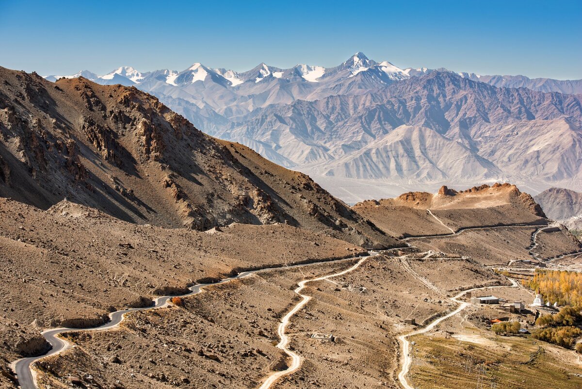
When you finally drive down into Leh, the landscape transitions from raw, open plains to a more populated setting. You’ll notice monasteries perched atop hills, the Indus River flowing nearby, and the city’s unique mix of traditional Ladakhi homes and modern infrastructure.
Lesser-Known Stopovers and Hidden Gems
Beyond the usual suspects (Rohtang Pass, Sarchu, Baralacha La), are you curious about smaller spots that people rarely talk about?
- Gemur Monastery (near Jispa): A small monastery that you can visit in the morning before heading to Sarchu. Offers an intimate look at the local monastic lifestyle.
- Bhaga River Banks (Jispa): Some travelers set up a short riverside picnic. If you have time, it’s a peaceful spot to soak in the scenery.
- Jispa Rural Museum: A tiny museum showcasing local culture. You won’t find large exhibits, but it’s a quick introduction to Lahaul’s traditions.
- Tsokar Lake (Detour from More Plains): A salt lake accessible by a short detour from the More Plains. Spot migratory birds if you arrive at the right time.
These hidden gems might require small diversions or an additional hour in your schedule. But they often provide a unique perspective on the region’s culture and environment.
Accommodation and Food
Worried about where to stay? Unlike some remote regions, the Manali–Leh route has seen an uptick in tourism-oriented services.
Types of Accommodation
- Guesthouses and Homestays: Common in Manali, Keylong, Jispa, and Leh.
- Tented Camps: Especially around Sarchu and Pang. Amenities can be basic, but they are improving every year.
- Hotels: Mostly in Manali and Leh. Along the mid-route (like Jispa, Sarchu), options are more rustic.
If you prefer the comfort of attached bathrooms, book tented camps labeled “deluxe” at Sarchu. Otherwise, you’ll likely have to walk to a shared facility.
Food Options
- Local Dhabas: They serve simple meals—rice, lentils, vegetables, and sometimes a noodle soup called thukpa.
- Small Cafés: In Manali or Keylong, you may find places serving pasta or pizza adapted to local taste.
- Local Delicacies: In Ladakh, try momos (steamed dumplings) and butter tea (salty tea made with yak butter).
Tip: If you have specific dietary needs (vegan, gluten-free, etc.), carry some ready-to-eat meals or snacks. You may not always find specialized foods in the remote areas.
Local Etiquette and Culture
Despite the rugged journey, remember that each village you pass through has its own social norms.
- Dress Modestly: While there’s no strict dress code, being respectful goes a long way.
- Engage Politely: Learn a few basic greetings. In Ladakh, “Juleh” is a common greeting that covers hello, goodbye, and thank you.
- Photography: Always ask for permission before photographing local people or private property.
- Monastery Visits: Remove your shoes and remain quiet. If you’re unsure about customs, ask the caretaker or a local guide.
Side Trips from Leh
Arriving in Leh is not the end of the adventure. Many travelers use Leh as a base for smaller excursions in the region. Are you wondering which ones are worth it?
- Nubra Valley:
- Distance from Leh: ~120 km via Khardung La (5,359m).
- Highlights: Sand dunes at Hunder, double-humped Bactrian camels, and Diskit Monastery.
- Pangong Tso:
- Distance from Leh: ~160 km (via Chang La, 5,360m).
- Highlights: Ever-changing colors of a high-altitude brackish lake. Some sections now have tented accommodations.
- Tso Moriri:
- Distance from Leh: ~220 km.
- Highlights: A quieter, less-visited high-altitude lake. Great for spotting migratory birds.
Remember that Inner Line Permits (ILP) might be necessary for these areas. Check with the Ladakh Tourism Office or your guesthouse for the latest requirements.
Essential Travel Tips
Curious about how to ensure a hassle-free trip? Here are some pointers:
- Start Early: Aim to be on the road by 6 or 7 a.m. This gives you a buffer in case of landslides or traffic near passes.
- Stay Updated: Road conditions can change daily. The Border Roads Organization (BRO) often issues updates on social media or local bulletins.
- Respect the Altitude: Don’t ignore symptoms like persistent headache or nausea. Descend if needed.
- Carry Cash: ATMs can be found in Manali, Keylong, and Leh, but they might run out of cash or have connectivity issues.
- Avoid Night Driving: The roads are not well-lit, and sudden weather changes can occur.
Suggested Itineraries
While the classic three-day itinerary works for many, not everyone travels at the same pace. Below are a couple of alternative plans:
4-Day Itinerary (Relaxed Pace)
- Day 1: Manali → Keylong (stay)
- Day 2: Keylong → Jispa (short drive, more exploration time)
- Day 3: Jispa → Sarchu (stay)
- Day 4: Sarchu → Leh
This plan allows more rest and a chance to explore local monasteries or go on short hikes.
2-Day Itinerary (Fast but Demanding)
- Day 1: Manali → Keylong → Jispa → Sarchu (stay)
- Day 2: Sarchu → Leh
If you’re short on time, you can push through in two days. However, altitude sickness and fatigue are more likely.
Common Questions and Realities
You might have come across social media posts showing empty roads and glorious sunsets. But what’s the reality on the ground?
Q: Is Rohtang Pass always crowded?
A: During peak summer (June-July), Rohtang Pass draws a lot of tourists. Start early from Manali to avoid traffic jams.
Q: Are the roads as dangerous as people say?
A: There are rough stretches, hairpin bends, and high-altitude passes. If you drive cautiously and maintain your vehicle well, it’s manageable. The BRO does a commendable job in maintaining these roads each season.
Q: Can I find fuel easily along the route?
A: Fuel stations are limited. The main one is at Tandi, and there’s also a facility in Keylong. After that, your next reliable station is in Leh. Some dhabas may keep spare fuel in cans, but it might be more expensive.
Q: What about mobile connectivity and internet?
A: You can expect patchy coverage. In Manali and Leh, you’ll find stable networks. Between these towns, signals might be weak or nonexistent. Carry a postpaid SIM from major providers like BSNL or Airtel, as prepaid connections (especially from outside J&K and Ladakh) may not work in some areas.
Cost Estimation and Budget Planning
Everyone’s budget varies, but here’s a rough outline to help you plan.
- Fuel Costs:
- A round trip from Manali to Leh and back could cover around 1,000+ km if you also visit local areas near Leh. Depending on your vehicle’s mileage, budget roughly INR 4,000–8,000 for fuel (for a car or SUV).
- For a motorcycle, it might be INR 2,000–4,000, depending on the engine capacity and mileage.
- Accommodation:
- Manali and Leh: You can find budget rooms for INR 800–1,500 per night, while mid-range hotels range between INR 2,000–3,000. Upscale options can go higher.
- Keylong/Jispa/Sarchu: Tented camps or homestays can cost between INR 1,000–2,500 per night, depending on amenities.
- Food:
- Local dhabas offer meals for around INR 100–200.
- Restaurants in Manali or Leh could cost INR 300–600 per person for a more varied menu.
- Permits:
- Inner Line Permits in Ladakh usually cost between INR 400–600, including environment fees.
- Miscellaneous:
- Medical Kit: INR 200–500.
- Snacks and Water: INR 500–1,000 for an entire trip if you buy bottled water (carrying your own water filtration solution can save cost and plastic waste).
Pro Tip: Always keep a contingency fund for unforeseen expenses like vehicle repairs or additional night halts due to road closures.
Staying Safe and Healthy
High altitudes bring specific risks, but with the right approach, you can minimize them.
Altitude Sickness (AMS)
- Symptoms: Headache, dizziness, nausea, fatigue, and shortness of breath.
- Prevention: Climb gradually, stay hydrated, avoid alcohol, and rest well.
- Action: If symptoms worsen, descend to a lower altitude or seek medical attention. Oxygen cylinders or cans can be purchased in Manali or Leh, but consult a medical professional on their correct usage.
General Road Safety
- Drive at a Moderate Speed: This isn’t the place for racing.
- Check Weather Forecasts: Rain or snow can turn roads slippery in minutes.
- Have a Backup Plan: Be prepared to change your itinerary if a pass closes unexpectedly.
Food and Water Safety
- Eat Freshly Cooked Meals: Look for popular dhabas, as higher turnover means fresher food.
- Use Filtered Water: Or bring purification tablets. Avoid drinking water straight from streams if you’re unsure of its source.
Final Thoughts
A Manali–Leh Ladakh road trip can be an eye-opening experience. It introduces you to environments and cultures you might not encounter in typical tourist hubs. Even the smaller details—like stopping for a chai at an unassuming roadside shack—can become highlights of your journey.
Will you need patience for bumpy sections of the road? Certainly. Are you likely to encounter unpredictable weather? Quite possibly. But if you’re prepared, flexible, and open-minded, the route can reward you with moments that make every mile worth it.
If you’ve ever wondered whether you can handle the Himalayas, this route is a crash course in mountain road travel. It’s a literal and metaphorical ascent, taking you from the green valleys around Manali into the high-altitude deserts of Ladakh.
The question is: Are you ready to experience the highs and lows—both figuratively and literally?
References
- Himachal Pradesh Tourism Official Website
https://himachaltourism.gov.in/ - Ladakh Tourism Official Website
https://tourism.ladakh.gov.in/ - India Meteorological Department (IMD) – Weather Updates
https://mausam.imd.gov.in/ - Border Roads Organization (BRO) – Road Status and Updates
https://bro.gov.in/ - Incredible India – General Travel Information and Tips
https://www.incredibleindia.org/ - National Center for Seismology (Altitude/Environmental Data)
https://seismo.gov.in/