Kedarnath Travel Guide: A Story-Rich Journey to the High Himalaya’s Most Moving Pilgrimage
If you’ve ever wondered what it feels like to walk toward a shrine that seems to sit at the edge of the world, Kedarnath has an answer waiting for you. Not a neat, postcard answer—but one that comes in thin air, steady footsteps, and a sudden hush you didn’t expect to find inside yourself.
This is a place where travel looks like pilgrimage even if you don’t arrive with that word on your lips. You might come for devotion, for the Kedarnath trek, for snow-melt rivers and big mountains, or for a quiet kind of reset you can’t quite name. Whatever your reason, Kedarnath meets you honestly. It asks for effort. It gives back something harder to describe.
Let’s plan your journey in full—how to reach Kedarnath, how the trek really feels, what to do beyond the temple, where to stay, what to pack, how to keep safe, and how to make the most of every hour in the valley—with the kind of detail you’ll want when you’re actually there.
Table of Contents
Where You Are Going (and Why It Feels Different)
Kedarnath sits at around 3,584 meters (11,755 feet), cradled by steep Himalayan walls and watched over by the Kedar peak and the Chaukhamba range. The town is small, seasonal, and completely defined by the shrine at its center.
But what makes it feel different isn’t only the altitude or the temple’s granite calm. It’s the approach. Kedarnath is earned, not consumed. For most travelers, reaching it means walking 16–18 km uphill from Gaurikund. That slow arrival changes your relationship to the landscape. Your mind has time to catch up to your body. The valley unfolds in chapters.
You’ll notice this on the trail—people talking less as they climb, strangers sharing water without a blink, older pilgrims finding rhythm in mantras, kids counting mules, and trekkers realizing their phones matter less than they thought.
So before we get into logistics, ask yourself: what pace do you want your Kedarnath story to move at? Fast, via helicopter? Steady and traditional on foot? With a night halt mid-way? There’s no right answer. There’s only the one that fits your body, time, and intention.
Best Time to Visit Kedarnath (Season by Season Truth)
Kedarnath is not open year-round. The temple and settlement operate in a narrow window because winter snow makes roads and trails unsafe. Each year the opening and closing dates are announced based on the Hindu calendar, but the pattern is consistent:
- Opening: usually late April or early May (around Akshaya Tritiya)
- Closing: usually late October or early November (around Bhai Dooj)
Here’s how the seasons feel on the ground:
May to mid-June: Clear skies, busy trails
This is peak season and for good reason. Days are bright, nights are cold but manageable, and the trail is fully active with services. Snow may still sparkle on upper ridges, and the valley feels freshly awake after winter.
Expect: crowds, high demand for stays, long lines for darshan, and lively trail energy. If you’re okay with people and want the most stable weather, this is your window.
Late June to early September: Monsoon mood
The valley turns green and intense, but so do landslide risks. Rain can be relentless, cloud cover thick, and trail closures happen without much warning.
Go in monsoon only if you are flexible and experienced. Many travelers avoid it, and that’s a wise call unless you have strong reasons.
Mid-September to late October: Crisp air, quieter trails
This is the sweet spot. The rains retreat, skies open up, and crowds thin out. Days are cool, nights can drop below freezing, and the mountains look sharper.
If you’re chasing a calmer Kedarnath—longer silences, more space by the river, an easier darshan queue—this is your season.
Registration You Must Do Before You Start
Yes, it’s mandatory. The state requires all pilgrims and travelers to register for the yatra for safety and crowd management.
Registration is free and can be done:
- Online via the official Uttarakhand portal
- At designated offline counters in major yatra hubs (Haridwar, Rishikesh, Sonprayag, etc.)
Carry a valid ID (Aadhaar, voter ID, passport, etc.) and keep a soft and hard copy of your pass/QR confirmation. You’ll be checked at multiple points.
How to Reach Kedarnath: The Real Route, Not the Shortcut Version
Kedarnath doesn’t have a road that goes all the way up. You’ll reach the road-head at Sonprayag, then a short shuttle to Gaurikund, then the trek begins.
Step 1: Get to Haridwar / Rishikesh
These are the main gateways.
- By train: Haridwar and Rishikesh are well-connected from Delhi, Mumbai, Kolkata, and other major cities.
- By air: Nearest airport is Jolly Grant (Dehradun)—about 35 km from Rishikesh and ~225 km from Sonprayag by road.
Step 2: Road to Sonprayag
From Haridwar/Rishikesh, the road journey to Sonprayag is long but scenic—roughly 8 to 10 hours, depending on traffic and weather.
Route highlights you’ll pass: Devprayag, Rudraprayag, Agastyamuni, Guptkashi. You’ll see river confluences, hanging cliffs, and small towns that feel more like rest-stops between worlds.
Pro tip: If your body doesn’t love sudden altitude jumps, break the journey with a night halt in Guptkashi or Phata.
Step 3: Sonprayag to Gaurikund
Private vehicles stop at Sonprayag. From there:
- Take a shared jeep or local shuttle to Gaurikund (about 5–6 km).
- This stretch is tightly controlled during peak season.
Gaurikund has a lively bazaar vibe—chai stalls, raincoats, bamboo walking sticks, last-minute ponies, and a restless hum of starting-line energy.
The Kedarnath Trek: A Stage-by-Stage Walk You’ll Remember
Distance: about 16–18 km depending on route tweaks
Time: 6–9 hours for most people
Difficulty: moderate, partly steep, at high altitude
Start altitude: ~1,980 m at Gaurikund
End altitude: ~3,584 m at Kedarnath
The trail has been rebuilt and reinforced after natural disasters, and today it’s broad, marked, and supported with medical posts, shelters, and food stalls.
Let’s walk it together.
Stage 1: Gaurikund to Jungle Chatti (≈4 km)
The trail rises quickly through forested bends. You pass the Mandakini’s roar below, cross bridges, and settle into your climbing rhythm.
Early morning here feels special. You’ll hear bells from mule caravans, the murmur of pilgrims, and the occasional hush of pine.
Pause for: your first proper breath check. If you’re getting winded too early, slow down now. Kedarnath rewards patience.
Stage 2: Jungle Chatti to Bhimbali (≈3–4 km)
This stretch opens up. You begin seeing waterfalls threading down rock faces, and the valley widens just enough to let light pour in.
Bhimbali is a major rest stop with shelters, dhabas, and medical aid. If you’re doing a two-day ascent, this is one common night-halt zone.
Snack moment: try hot aloo paratha or simple dal-chawal here—comfort food is fuel in these altitudes.
Stage 3: Bhimbali to Linchauli (≈3–4 km)
Now the trail becomes more alpine. Vegetation thins; wind feels colder. The river is more visible, sometimes dramatic, sometimes quiet.
Linchauli has tent clusters and basic lodges. Even if you aren’t staying, it’s a great long break point.
Watch for: tiny wildflowers in season and grey langurs sitting like thoughtless guardians along the ridge.
Stage 4: Linchauli to Kedarnath Base (≈4 km)
This part feels longer than it is. The air is thinner, and your backpack suddenly feels more honest about its weight.
You’ll pass:
- Rudra Point
- Broad gravel beds
- Rolling climbs with scattered stalls
At last, you hit the base area where the settlement begins. The first sight of the Kedarnath valley is subtle—you don’t arrive in one dramatic moment. You sort of cross a final bend and realize the mountains have been waiting quietly the whole time.
Final stretch: Base to Temple (≈1 km)
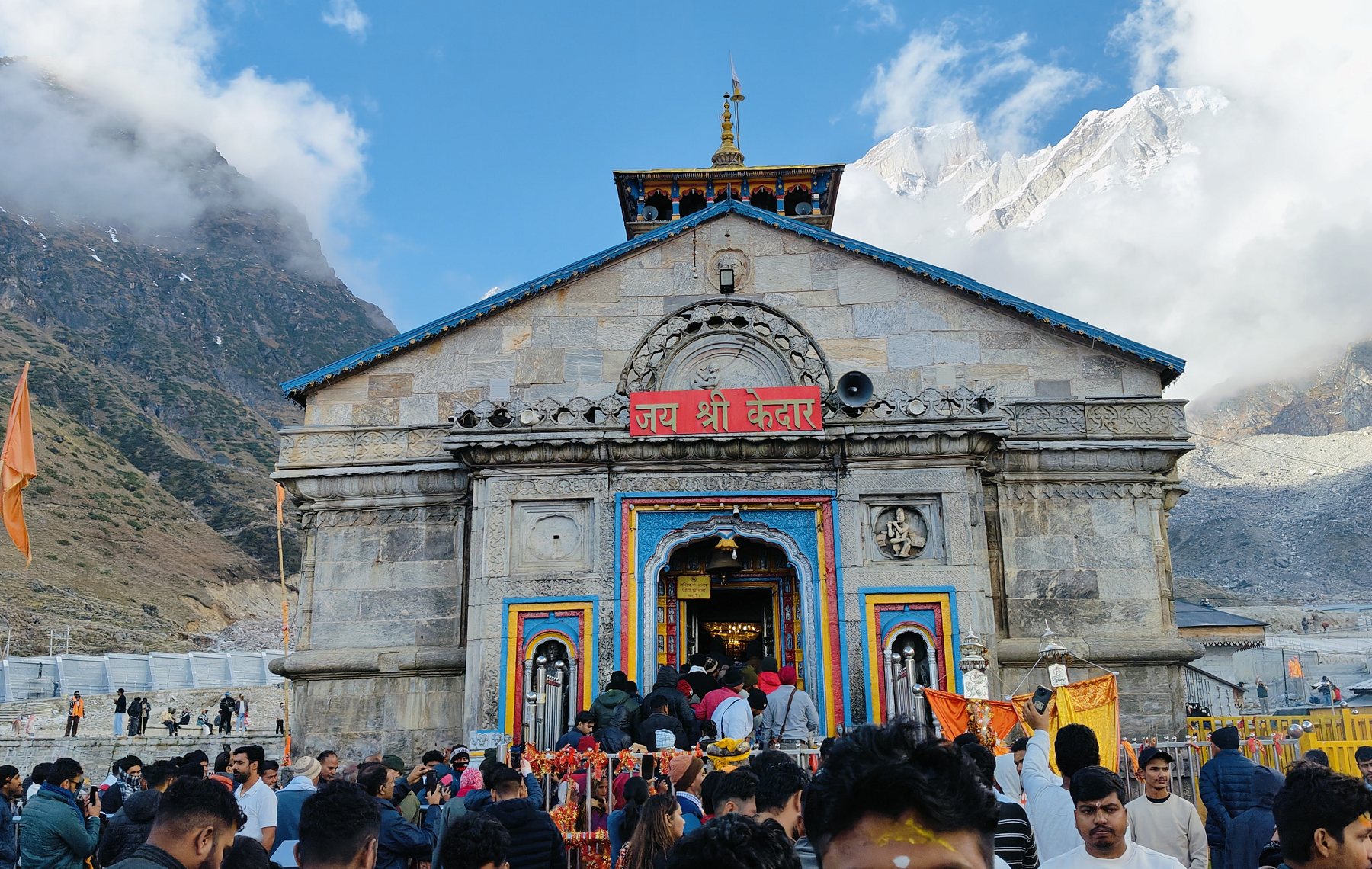
Short but steep in parts. The temple shows up against the mountain wall like a promise kept. People go quiet here. Even if they don’t mean to.
Trek Alternatives: Pony, Palki, Kandi, Helicopter
Not everyone wants—or can—walk up. Kedarnath has options:
- Ponies / mules: common, book at Gaurikund. Expect a bumpy ride and a long queue in peak season.
- Palki (palanquin): carried by porters, good for seniors or those with injuries.
- Kandi: basket-style carry (rare now, mostly for kids).
- Helicopter: fastest way up.
If you choose helicopter travel, remember:
- Book only through the official IRCTC heli portal. Fake booking sites are common.
- Flights are highly weather-dependent.
- Allow a buffer day in your itinerary in case of cancellations.
Where to Stay: From Base Towns to Kedarnath Itself
You’ll need at least one night before and after the trek. Here’s the landscape of stays.
Guptkashi & Phata: The smart acclimatization stops
These towns are lower, better supplied, and easier on the wallet.
You’ll find:
- guesthouses
- mid-range hotels
- dharamshalas
- restaurants and ATMs
If you’re traveling with elders, kids, or anyone unsure about altitude, sleep here a night before you climb.
Sonprayag: Functional overnight
Sonprayag is crowded in season and mostly serves as a transit hub. Rooms can be basic.
Good for: late arrivals who want to start trekking early the next morning.
On the trek (Bhimbali / Linchauli)
Tents and shared shelters are available. They’re simple but lifesaving for two-day trekkers.
This is a great option if:
- you want to reduce strain
- you’re trekking with family
- you want a slower, more reflective ascent
Kedarnath town
Stays here are seasonal and get booked out fast.
Types of accommodation:
- GMVN camps and prefabricated huts
- private lodges
- shared dorms
- basic guesthouses
- tent colonies
Expect simple bedding, limited water, and cold nights even in summer. But also expect a kind of atmosphere you can’t buy in cities—the valley has its own hush after sundown.
Food in Kedarnath and on the Trail
You won’t go hungry. The trail has frequent dhabas and tea stalls.
Typical trail food:
- aloo paratha, poori-sabzi
- dal-chawal
- maggi and soup (yes, still a thing up here)
- lemon tea, ginger tea, black tea
- biscuits, bananas, boiled eggs (at lower stops)
In Kedarnath town:
- vegetarian meals only
- simple thalis
- prasad stalls
- hot milk and herbal teas in the cold evenings
Tip: carry a small packet of dry fruits, jaggery, or energy bars. Your body will ask for quick calories above Linchauli.
What to Do in Kedarnath (Beyond Just “Visit the Temple”)
Yes, the temple is the core. But Kedarnath isn’t one experience—it’s many, layered in a small valley.
1. Darshan at Kedarnath Temple

Try to visit at least twice:
- once in the calm morning
- once at dusk when the air turns sharp and the lamps start to glow
Temple routine: early morning rituals begin before dawn; there’s a midday break; evenings are for aarti and quieter darshan. Times vary slightly by season and crowd flow.
Ask yourself while you sit in the courtyard: was it the climb that changed you, or the stillness once you arrived?
2. Bhairavnath Temple
A short, steep walk above the main town.
It’s a superb viewpoint and also a significant shrine.
Go in the late afternoon and watch Kedarnath below slowly empty into twilight. The wind here has a personality.
3. Shankaracharya Samadhi
Near the temple complex lies a memorial said to mark Adi Shankaracharya’s final resting place. Even if you’re not drawn to the story, the spot has quiet gravity.
4. Bhim Shila
A huge boulder near the shrine, venerated for having protected the temple during devastating floods. People stop here instinctively, as if to say thanks to the mountain itself.
5. Mandakini River Walk
Kedarnath evenings are for wandering softly by the river. The Mandakini isn’t just scenery; it carries the valley’s pulse.
Look for:
- small prayer circles
- pilgrims warming hands on tea glasses
- the way clouds cling to rock faces like slow smoke
6. Gandhi Sarovar (Chorabari Tal)
A ~3–4 km trek from Kedarnath, gentle enough for most fit travelers.
The path crosses alpine meadows and stone ridges. The lake is glacial, calm, and intensely high-altitude. In good weather, reflections of the peaks sharpen the silence.
Go early. The afternoon wind can be rough.
7. Vasuki Tal
For strong trekkers only.
This is a higher-altitude lake trek that usually needs a full day or a night-camp plan. The trail is more rugged and far quieter than the main yatra path.
If you want Kedarnath without crowds—Kedarnath as a wilderness story—this trek is your gateway.
8. Stargazing
Clear nights here are startling. Kedarnath has minimal light pollution once the shops shut.
Step away from the main cluster, look up, and you’ll see the Milky Way as a wide river of frost across the sky.
The Kedarnath Wildlife Sanctuary: Nature All Around You
Even if you don’t call yourself a wildlife person, the sanctuary is part of your journey. The entire trek passes through protected habitat.
This area is also known as the Kedarnath Musk Deer Sanctuary, spread across alpine forests, meadows, and high ridgelines.
You might spot:
- Himalayan monals
- langurs
- bharal (blue sheep), if you’re lucky
- rare alpine flora in summer
Responsible travel here matters. Don’t litter, avoid loud music, and stay on marked paths. The valley’s fragility is real.
Nearby Places Worth Adding to Your Kedarnath Itinerary
Kedarnath fits beautifully into a longer Kedar valley trip. Here are places that deepen the story.
Triyuginarayan Temple
About an hour from Guptkashi by road, this village shrine is tied to the lore of Shiva and Parvati’s wedding.
Even if you’re not following the legend, the setting is unmatched: terraced slopes, quiet lanes, and a gentler altitude before or after Kedarnath.
Guptkashi
Often treated as a stopover, but it’s worth more.
Visit:
- Vishwanath Temple
- peaceful river views
- markets for woolens and local snacks
Guptkashi is also a good place to rest and acclimatize.
Ukhimath
A serene town where Kedarnath’s deity is worshipped during winter closure. Come for the quiet, stay for the slow pace.
Chopta–Tungnath–Chandrashila
If you can spare a day or two, this route is one of the most rewarding in Uttarakhand. Tungnath is the world’s highest Shiva temple; Chandrashila adds a panoramic ridge walk.
It complements Kedarnath perfectly: less crowd, more meadow, and a different kind of elevation.
Deoria Tal
A reflective lake near Chopta that feels like a postcard you can walk into. Great for sunrise, easy trekking, and camping.
Sample Kedarnath Itineraries (Pick Your Rhythm)
Option A: Classic 3-Day Kedarnath Trip
Day 1: Reach Guptkashi/Phata, rest, register, early sleep
Day 2: Drive to Gaurikund, trek to Kedarnath, evening darshan
Day 3: Morning darshan, descend to Gaurikund, return to Guptkashi
Option B: Easier 4–5 Day Plan (with acclimatization)
Day 1: Reach Guptkashi
Day 2: Optional Triyuginarayan / local rest
Day 3: Trek to Kedarnath (night stay)
Day 4: Gandhi Sarovar, Bhairavnath, relaxed darshan
Day 5: Descend and return
Option C: Kedarnath + Nature Extension (6–7 Days)
Days 1–2: Guptkashi + Triyuginarayan + acclimatization
Day 3: Trek to Kedarnath
Day 4: Vasuki Tal day trek or sanctuary walk
Day 5: Descend
Days 6–7: Chopta–Tungnath–Chandrashila loop
Altitude, Health, and Safety: What You Actually Need to Know
Kedarnath is high enough to humble fit people. Respect the altitude.
Common altitude effects:
- headache
- nausea
- breathlessness
- sleeplessness
- unusual fatigue
What helps:
- slow trekking pace
- hydration (small frequent sips)
- light meals
- avoiding alcohol and smoking
- sleeping a night at Guptkashi/Phata before ascent
- carrying Diamox only if prescribed by a doctor
If symptoms worsen, descend immediately and seek medical help. There are medical posts along the trail and in Kedarnath.
What to Pack for Kedarnath
You don’t need fancy gear. You need smart gear.
Essentials:
- warm layers (even in May)
- waterproof jacket or poncho
- sturdy trekking shoes with grip
- walking stick (buy in Gaurikund if you don’t have one)
- wool cap and gloves
- quick-dry socks (2–3 pairs)
- small first-aid kit
- headlamp/torch
- sunscreen + lip balm
- reusable water bottle
- power bank
Nice-to-have:
- light thermals for night
- electrolytes
- rain cover for bag
- lightweight sleeping liner if you’re sensitive to shared bedding
Budgeting in Kedarnath
Costs shift by season, but here’s the realistic picture:
- Road travel: buses are cheapest, private taxis cost more but save time.
- Stays: Guptkashi/Phata cheaper; Kedarnath pricier due to logistics.
- Food: generally affordable, but snacks add up on trail.
- Pony/palki/helicopter: premium costs, book early in peak season.
Rule of thumb: keep a buffer. Weather or fatigue can add an unplanned night mid-way.
Responsible Kedarnath Travel
This valley has survived harsh weather and heavy footfall. It deserves care.
Please:
- carry your trash down
- avoid plastic bottles if possible
- don’t play loud music on the trail
- respect wildlife and local customs
- stay on the designated route
- support local homestays and small dhabas when you can
A simple act like refilling a bottle instead of buying another—multiplied by thousands of travelers—matters here.
Practical FAQs
Is Kedarnath safe for first-time trekkers?
Yes, if you pace yourself, stay hydrated, and consider a night halt mid-way. The trail is supported and well-marked.
Can kids or seniors do Kedarnath?
Many do—especially with acclimatization and assistance (pony/palki). Always check medical fitness first.
Is mobile network available?
Patchy. Some spots have coverage, but don’t rely on it. Carry offline maps and inform family beforehand.
Do I need to book accommodation in advance?
In peak season, absolutely. In shoulder season, you might find spots on arrival, but booking reduces stress.
A Final Thought Before You Go
Kedarnath isn’t a place you “finish.” It’s a place you carry.
You’ll remember the rhythm of your breath on the climb. The way the river never stops talking. The first time you see the temple’s stone front against a cloud-wrapped ridge. The tea that tastes oddly sweet after hours of walking. The quiet right after the aarti ends, when even the mountains seem to listen.
So when you plan your Kedarnath trip, plan for the logistics—but also leave space for surprises. The valley has a way of giving you exactly the journey you didn’t know you needed.
References
- Shri Badarinath Kedarnath Temple Committee – Official Yatra Updates, Registration & Heli Portal
https://badrinath-kedarnath.gov.in/ - Uttarakhand Tourism – Kedarnath Destination Overview
https://uttarakhandtourism.gov.in/destination/kedarnath - Rudraprayag District Administration – Kedarnath Yatra Information
https://rudraprayag.gov.in/kedarnath-yatra-2/ - IRCTC Official Heli Yatra Portal – Authorized Helicopter Booking
https://heliyatra.irctc.co.in/ - Gaurikund–Kedarnath Trek: Distance, Stages & Checkpoints – Udan Aviation
https://www.udanaviation.in/blog/gaurikund-to-kedarnath-trek/ - Chardham Travel Information (Additional Trek & Yatra Details)
https://www.chardham.in/ - Kedarnath Wildlife Sanctuary – Government Overview
https://kedarnathwildlife.uk.gov.in/pages/about-us - Kedarnath Wildlife Sanctuary – Wikipedia
https://en.wikipedia.org/wiki/Kedarnath_Wildlife_Sanctuary - Gandhi Sarovar / Chorabari Tal Trail – Club Mahindra Guide
https://www.clubmahindra.com/blog/places-to-visit/tourist-places-in-kedarnath - Places & Experiences Around Kedarnath – ShrineYatra
https://www.shrineyatra.in/things-to-do-in-kedarnath - Triyuginarayan Temple – eUttaranchal Travel Guide
https://www.euttaranchal.com/tourism/places-to-see-in-triyugi-narayan-temple.php


