Sedona, Arizona Travel Guide: 37 Unmissable Things to Do, Smart Planning Tips & Local Secrets
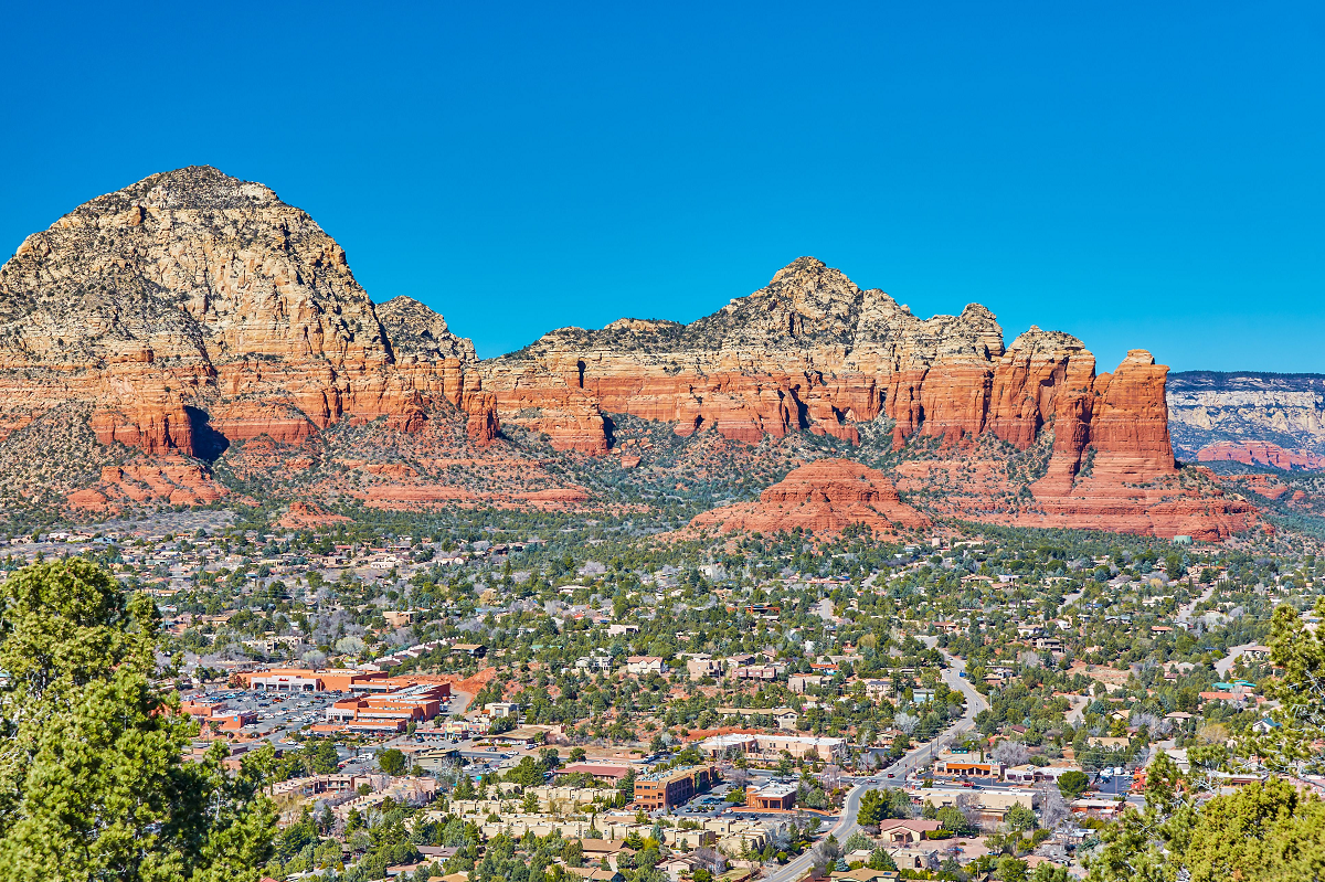
Sedona stirs the senses from the moment you arrive: dawn light paints cathedral-shaped buttes in ochre and rose, juniper fragrance breezes past, and a free shuttle is already idling to carry you to your first trailhead. That image can become your next long weekend, and this guide will make sure every minute counts. Ready to build a Sedona trip that feels effortless? Let’s dive in
Table of Contents
When Should You Visit—and Why Does It Matter?
Spring (mid-March through May) delivers 70 °F afternoons and slopes peppered with lupine and prickly-pear blooms. It’s the busiest stretch, so pre-dawn starts secure parking and cooler hiking temps.
Summer (June to early September) means triple-digit spikes and afternoon monsoon bursts that drop half the region’s annual rain. Hike at sunrise, nap after lunch, and watch storm lightning from a shaded patio.
Fall (late September through October) brings golden cottonwoods along Oak Creek and 80 °F highs—ideal for all-day mileage.
Winter (November through February) trades crowds for 55 °F afternoons and the occasional dusting of snow on the sandstone, creating surreal photo ops.
Wondering about averages? Daytime highs swing from 56 °F in January to 97 °F in July, with lows around 31–64 °F.
Getting to Sedona—and Moving Once You Arrive
Flying & Driving
- Phoenix Sky Harbor International (PHX) —two hours south on I-17; dozens of daily non-stops.
- Flagstaff Pulliam (FLG) —45 minutes north; small but closer.
Rent a car for maximum flexibility, yet know that you can ditch the wheel for peak trailheads thanks to the city’s Sedona Shuttle.
Sedona Shuttle: Your Congestion Hack
Since 2023, free buses run from Thursday–Sunday year-round (daily during spring break and winter holidays). Routes connect Park-and-Ride lots with Cathedral Rock, Soldier Pass, Devil’s Bridge (via Mescal), and Little Horse trailheads. During operating hours, the lots at Cathedral Rock and Soldier Pass close completely—no exceptions. Shuttles roll roughly 6:30 a.m.–8:30 p.m.; live bus locations appear in the TransLoc app.
Parking Reality Check
If you insist on driving, trailhead spaces fill by 6 a.m. on spring Saturdays. Always pack a “Plan B” hike reachable from the same corridor (example: Fay Canyon if Bear Mountain is maxed out).
Permits, Passes & Fees—Explained Without a Table
- Red Rock Pass – Covers day-use parking on most Coconino National Forest land around Sedona. Buy at trailhead kiosks or online for US $5 /day, $15 /week, or $20 /year. America the Beautiful passes are accepted.
- Soldier Pass Motorized Permit – The forest caps 4×4 traffic on Soldier Pass Road to protect soil; book a free time-stamped permit on Recreation.gov up to 14 days out.
- State-Park Entry – Slide Rock and Red Rock State Parks charge per-vehicle fees that rise to US $30 in summer peak.
Tuck the receipt on your dash, or rangers may ticket—even at dawn.
Where to Stay: Three Distinct Home Bases
- Uptown Sedona – Walkable strip of cafés, galleries, and shuttle stops; perfect if you’d rather forget your rental key.
- Village of Oak Creek (VOC) – Eight miles south; handy for Bell Rock trails and lower rates.
- West Sedona – Local vibe, Whole Foods for trail snacks, and instant access to Dry Creek trailheads.
Camping? Reserve Manzanita or Cave Springs six months ahead; dispersed spots on Forest Road 525 are first-come but often full by Friday noon.
The 10 Headline Hikes—Step-by-Step Breakdown
1) Cathedral Rock Ascent
Round-trip: 1.4 mi | Gain: 740 ft.
Why go? The saddle view frames buttresses like a natural amphitheater. Expect hands-and-feet scrambling in the last 30 ft—rubber-soled shoes only. Shuttle required Thu–Sun.
Pro tip: Shoot photos 20 minutes after sunrise for golden under-lighting on the spires.
2) Devil’s Bridge via Mescal
Round-trip: 4.2 mi.
The city added shuttle service in 2024; parking closes Thu–Sun. Stand on the sandstone arch for the famous illusion of clinging to a thin ribbon—just be courteous and limit photo sessions to one minute when lines form.
3) Bell Rock & Courthouse Butte Loop
A 4-mile beginner route with constant 360-degree views. Start clockwise to keep morning shade on the exposed east side. Cyclists zip past at dawn—stay alert.
4) Boynton Canyon & the Subway Cave
6.6 mi out-and-back into Sedona’s greenest box canyon; side path at mile 2 climbs to a wave-shaped alcove locals call the Subway. Observe posted signs—this is Yavapai-Apache heritage.
5) Soldier Pass & Seven Sacred Pools
Itinerary: Devil’s Kitchen sinkhole, the ripple-edged pools, then a spur to the secret Sphinx rock. Arrive before 7 a.m. or use the shuttle because the lot has only 14 spaces.
6) Bear Mountain
A calf-burning 4.3-mi ascent to 6,572 ft; the summit towers 1,500 ft above Boynton Canyon. Carry at least 3 L of water—there’s zero shade.
7) Doe Mountain
A one-mile staircase to a flat mesa top where ravens ride thermals at eye level—ideal picnic perch.
8) Brins Mesa
Climb through piñon pine to a grassy mesa and spur paths toward Seven Sacred Pools. Wildflowers peak in late April.
9) Munds Wagon to Merry-Go-Round Rock
Expect slickrock ledges and view decks used by wedding photographers. Reach the final mile with a high-clearance 4×4 or book a jeep tour.
10) Fay Canyon Arch
Easy 2.4 mi stroll ends at a natural arch; scramble up the left side for a window across the canyon.
Craving More Than Hiking? Pick Your Thrill
Pink Jeep Broken Arrow Tour
Iconic hot-pink Wranglers bounce down sandstone steps named “The Road of No Return.” Only Pink Jeep holds the permit for this route, making each seat a hot commodity. Book at least a week ahead during spring and fall.
Mountain Biking Paradise
Sedona is “Moab with flow.” Rent a full-suspension bike in West Sedona; test beginner legs on Bell Rock Pathway, graduate to Slim Shady, then try the expert-only Hi-Line—with narrow singletrack and huge exposure. Pack a derailleur hanger; limestone blocks love to snap them.
Dawn Hot-Air Balloon Flights
Companies launch around 5 a.m., float above the Mogollon Rim at 2,000 ft, and land before thermals kick up. Bring layers: temps aloft run 15 °F cooler.
Stargazing in an International Dark-Sky Community
Sedona earned its IDA badge in 2014 by capping street-light wattage. Lay a blanket at Crescent Moon Picnic Site, kill phone screens, and catch the Milky Way’s bright core between April and September.
Water Therapy
Slide Rock State Park turns Oak Creek into a natural waterslide; arrive at 9am gate-open to beat the US $30 summer fee and midday crowds. Want solitude? Hike 1 mi upstream to quieter plunge pools.
Spa time? Many resorts weave red-rock views into deep-tissue massages. Ask whether therapists are state-licensed—Arizona requires it.
Eat & Drink Like You Mean It
- Elote Café – Signature fire-roasted corn dip and smoked brisket enchiladas; reservations essential.
- Mariposa Latin-Inspired Grill – Architecture by chef Lisa Dahl frames a sunset deck facing Chimney Rock.
- Indian Gardens Café – Grab a breakfast burrito en route to Oak Creek Canyon, then refill trail water bottles for free.
- Oak Creek Brewery – Belgian-style amber and live patio music.
- Verde Valley Wine Trail – Page Springs Cellars, Javelina Leap, and Alcantara pour Rhône-style reds 20 minutes southwest; designate a sober driver or hire a shuttle.
Easy Day Trips That Super-Charge Your Itinerary
- Slide Rock State Park – Cool off in spring-fed chutes right inside Oak Creek Canyon (20 minutes north).
- Jerome – A former copper boomtown now packed with artist studios and mead tastings 35 minutes west.
- Montezuma Castle National Monument – 1,000-year-old cliff dwellings tucked into limestone; National Park Service rangers run hourly talks.
- Grand Canyon South Rim – Two-hour drive; leave Sedona at 4 a.m. for sunrise on Mather Point and be back by bedtime.
Three Perfect Ways to Structure Your Time
The “Sampler” Weekend (3 Days)
Day 1: Sunrise Cathedral Rock, brunch Uptown, Broken Arrow jeep thrill, sunset at Airport Mesa.
Day 2: Dawn Devil’s Bridge, chill coffee break, afternoon Doe Mountain, stargaze at Crescent Moon.
Day 3: Slide Rock splash, detour to Jerome, wine tasting, return for dinner at Mariposa.
The “Hiker’s High” Mid-Week (4 Days)
Add Bear Mountain summit, Soldier Pass pools, and relaxing vortex yoga at Bell Rock.
The “See-It-All” Vacation (7 Days)
Layer in Montezuma Castle, a Grand Canyon dash, a full-moon sound-bath concert, and an Oak-Creek fly-fishing lesson.
Which itinerary sparks your imagination?
Responsible & Safe Travel Checklist
- Hydrate hard: Three liters per hiker in summer heat.
- Respect monsoons: Storms drop walls of water that can flood dry washes in minutes. Check forecasts before canyon hikes.
- Leave No Trace: Pack out orange peels, stay on slickrock to preserve cryptobiotic soil.
- Mind the altitude: Sedona sits at 4,350 ft; pace uphill climbs if you’re coming from sea level.
- Cell service gaps: Download offline maps; carry a paper topo if venturing deep.
Why Sedona Is More Than a Pretty Face
Tourism drives roughly US $1 billion into Sedona’s economy and covers 77 % of local tax revenue. Visitors literally keep trailheads maintained and shuttles free—so your conscientious choices ripple outward.
Will you chase first light on Cathedral Rock or toast sunset from a vineyard deck? Either way, you’re stepping into a living laboratory of geology, ecology, and creativity. Pack curiosity, respect the land, and your Sedona story will write itself—one red-rock stride at a time.
Sources & Further Reading
- Sedona Shuttle FAQ, City of Sedona: https://sedonashuttle.com/how-to-ride/
- Sedona Shuttle routes & hours: https://sedonashuttle.com
- Coconino National Forest – Red Rock Pass details: https://www.fs.usda.gov/r03/coconino/passes
- Recreation.gov – Soldier Pass motorized permits: https://www.fs.usda.gov/detail/coconino/passes-permits/recreation/
- Slide Rock State Park fees & hours: https://azstateparks.com/slide-rock
- Pink Jeep Tours – Broken Arrow: https://www.pinkadventuretours.com/sedona-tours/broken-arrow
- International Dark-Sky Community designation: https://darksky.org/places/sedona-arizona-dark-sky-community/
- U.S. Climate Data – Sedona averages: https://www.usclimatedata.com/climate/sedona/arizona/united-states/usaz0209
- National Weather Service – Northern Arizona monsoon facts: https://www.weather.gov/fgz/monsoon-info
- AllTrails – Devil’s Bridge via Mescal: https://www.alltrails.com/trail/us/arizona/devil-s-bridge-via-mescal-trailhead–2
- AllTrails – Boynton Canyon Trail: https://www.alltrails.com/trail/us/arizona/boynton-canyon-trail
- Wikipedia (USGS data) – Bear Mountain elevation: https://en.wikipedia.org/wiki/Bear_Mountain_(Loy_Butte,_Arizona)
- MTB Project – Hi-Line Trail exposure notes: https://www.mtbproject.com/trail/593534/hiline-trail
- Visit Arizona – Jerome artist colony overview: https://www.visitarizona.com/places/cities/jerome/
- National Park Service – Montezuma Castle facts: https://www.nps.gov/moca/
- Sedona Chamber of Commerce – tourism economic impact: https://sedonachamber.com/changes-in-the-travel-industry-forecasted/
