San Francisco to Los Angeles Road Trip via the Pacific Coast Highway (PCH-Route 1): Helpful Evergreen Guide
If you’re dreaming of a West Coast drive where every curve reveals new ocean drama, this is the route. The Pacific Coast Highway—signed as California State Route 1 for most of the way—threads together sea cliffs, redwoods, tiny surf towns, wine country, and golden beaches. This guide is built to help you plan a San Francisco–to–Los Angeles journey you can actually drive, with clear routing, realistic day-by-day options, and practical advice that stands up year-round.
A quick orientation before we dive in:
- Direction: North-to-south keeps the ocean on your side of the road, making viewpoints and turnouts easier.
- Total distance & drive time: Depending on detours and side loops, expect roughly 450–500 miles and 9–10+ hours of pure driving—not counting stops. (Plan more; you’ll stop often.)
- Road conditions on Highway 1 can change. Landslides and repairs are part of coastal life, especially in Big Sur. Always check official Caltrans conditions before you go and be ready to detour via US-101.
Table of Contents
How to Use This Guide
You’ll get: a mile-by-mile feel for the route, 3–7 day itineraries, can’t-miss stops (major and minor), detour logic when closures pop up, safety and etiquette tips specific to Highway 1, and booking advice for high-demand sites (where to reserve ahead and where you can be spontaneous).
When to Go (and What Weather to Expect)
- Spring (Mar–May): Wildflowers, migrating gray whales off some headlands, changeable weather.
- Early Summer (May–July): The famous marine layer—that cool, low cloud/fog—often blankets the coast in the mornings, especially near San Francisco and along the central coast. Expect moody mornings and bright afternoons inland.
- Late Summer to Early Fall (Aug–Oct): Typically the clearest coastal skies and warmest beach days.
- Winter (Nov–Feb): Green hills and dramatic surf—but more rain, wind, and the occasional slide-related closure. Check conditions before you go.
Pro tip: Pack layers no matter the month. The coast can be 10–25°F cooler than inland on the same day.
Essential Driving Etiquette & Safety on Pacific Coast Highway
- Use turnouts. If five or more vehicles queue behind you on a two-lane road and passing is unsafe, you must pull into a turnout to let them pass. It’s the law, and it keeps everyone safer.
- Give trucks and RVs room. Larger vehicles take longer to stop; don’t cut in close.
- Expect narrow shoulders, blind curves, and wind. Keep speeds conservative, especially near Big Sur.
- Check tides before exploring pocket coves and obey posted warnings—surf and sneaker waves are real hazards on exposed beaches. (Local lifeguard and park advisories vary; heed on-site signage.)
PCH Route Overview: San Francisco to Los Angeles the Scenic Way
Starting Point: San Francisco. Exit the city via Hwy-1 through the Presidio and Sea Cliff, then over the bluffs of the Peninsula.
Segment 1: San Francisco → Half Moon Bay → Santa Cruz
Highlights you can actually do:
- Devil’s Slide & Pacifica State Beach: Quick cliffside viewpoints and a classic crescent of sand as you leave the city behind.
- Half Moon Bay: Farm stands, seasonal u-pick, and quiet beaches just off the highway.
- Santa Cruz: Choose between the classic Beach Boardwalk vibe, surfers at Steamer Lane, and sea lions lounging under the Santa Cruz Wharf. (If you’ve never heard several dozen sea lions barking at once, you will.)
Why stop: It eases you into the rhythm of the coast and breaks up a long day. Food, fuel, and coffee are abundant.
Segment 2: Santa Cruz → Monterey Peninsula (Pacific Grove, Monterey, Pebble Beach, Carmel-by-the-Sea)
You could spend a full day here and still feel rushed.
- Monterey Bay Aquarium: One of the best in the world. Buy tickets in advance; same-day in-person sales are not offered.
- 17-Mile Drive (Pebble Beach): A scenic loop (fee for cars) linking Lone Cypress, dramatic cypress groves, and surf-pounded points. Gates generally open sunrise–sunset. (Fee subject to change; confirm before you roll up.)
- Pacific Grove’s Asilomar boardwalks and tidepools.
- Carmel-by-the-Sea: Walkable village, white-sand beach, galleries, and fairy-tale cottages.
Point Lobos State Natural Reserve (just south of Carmel): Widely considered the crown jewel of California’s state reserves for coastal hiking, wildlife, and cove views. Hours typically 8 a.m.–7 p.m. (arrive early; parking is limited), with additional visitor information via the reserve and foundation pages.
Segment 3: Carmel → Big Sur Coast (Bixby, Pfeiffer Beaches, McWay Falls)
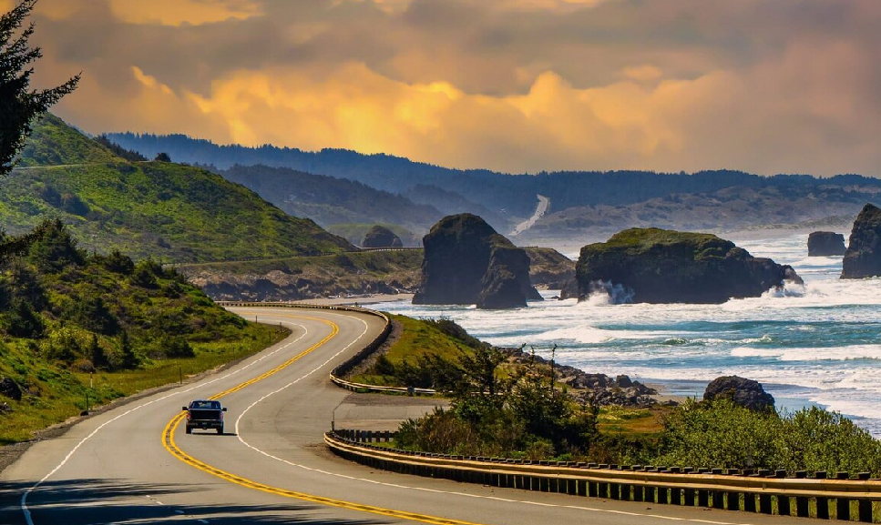
This is the stretch you picture when you hear “PCH.”
- Bixby Creek Bridge: Iconic arch bridge framed by turquoise coves. Pull into signed turnouts; never stop in traffic lanes.
- Pfeiffer Big Sur State Park: Redwoods and river canyons on the inland side.
- Pfeiffer Beach: Famous purple-tinted sand (from manganese garnet) and the Keyhole Arch. Access is via Sycamore Canyon Rd (narrow; use caution).
Important, long-running update for McWay Falls: At Julia Pfeiffer Burns State Park, the Overlook Trail to view McWay Falls is closed for a long-term retaining wall project (through 2026). Views are limited to a small roadside turnout on Highway 1; check the park’s official page for the current status, trail openings (like Ewoldsen), and parking info.
About closures in Big Sur: Slides and repairs happen; sections can be closed for months. If through-travel isn’t possible, you can still explore from both sides (Monterey/Carmel north side and Cambria/San Simeon south side) and connect inland via US-101. Always verify current closures and one-way controls on the Caltrans site before departure.
Segment 4: Big Sur (or Monterey/Carmel) → San Simeon → Cambria → Morro Bay → San Luis Obispo
Emerging from the cliffs, the coast softens into beaches and ranchland.
- Piedras Blancas Elephant Seal Rookery (north of San Simeon): Free, wheelchair-accessible boardwalks offer close, safe viewing year-round. Peak action cycles across winter births (late Jan), spring molts (around May), and fall haul-outs (late Oct).
- Hearst Castle: William Randolph Hearst’s lavish hilltop estate. Advance reservations strongly recommended; hours and tour offerings vary seasonally.
- Cambria: Pines, Moonstone Beach boardwalk, easy eats.
- Morro Bay: Working harbor, sea otters near the base of Morro Rock (observe wildlife from a distance).
- San Luis Obispo (SLO): Mission plaza, Thursday night farmers’ market (seasonal), and a lively downtown.
Segment 5: SLO → Pismo/Oceano → Guadalupe-Nipomo Dunes → Santa Maria Wine Country → Solvang → Santa Ynez
- Pismo/Oceano: Long beaches, Monarch butterfly grove (seasonal).
- Guadalupe-Nipomo Dunes: Towering coastal dunes; check access points and respect closures for habitat protection.
- Solvang: Danish-style village—bakeries, tasting rooms.
- Santa Ynez Valley: Pinot Noir and Chardonnay country (tasting rooms in Los Olivos, Santa Ynez, Buellton).
Segment 6: Gaviota → Santa Barbara → Carpinteria → Ventura/Oxnard (Channel Islands) → Malibu → Santa Monica → Los Angeles
- Santa Barbara: Spanish-revival architecture, beaches, and a compact downtown.
- Ventura/Oxnard—Gateway to Channel Islands National Park: Day trips (and camping) depart with Island Packers, the park’s official boat concessioner. Book ahead—services are limited on the islands and cell coverage is minimal.
- Malibu:
- Point Dume State Beach & Nature Preserve: Clifftop trails and seasonal whale watching (Dec–mid-Apr) from headlands.
- Robert H. Meyer Memorial State Beach pocket coves—El Matador, La Piedra, El Pescador—photogenic sea stacks and arches. Day-use lots generally open 8 a.m. to sunset; stairs are steep.
- Pacific Palisades: Getty Villa (time-ticketed museum; Greco-Roman art and gardens).
- Santa Monica: Pier, beach path, and the true urban arrival. From here you can roll right into the neighborhoods of Los Angeles.
Sample Itineraries (Realistic & Modular)
Classic 3-Day “Highlights” Itinerary
Day 1: San Francisco → Santa Cruz → Monterey/Carmel
- Coffee in Half Moon Bay, lunch at Santa Cruz’s harbor or downtown, Monterey Bay Aquarium in the afternoon, sunset at Carmel Beach. Buy aquarium tickets in advance.
Day 2: Carmel/Monterey → Big Sur (north half) → Carmel/Monterey
- Early parking at Point Lobos for a 2–3 hour hike. Continue to Bixby Bridge, Pfeiffer Big Sur State Park, and Pfeiffer Beach if time allows. Note McWay Falls Overlook remains closed; catch the limited view from the roadside turnout, if accessible.
Day 3: Carmel/Monterey → San Simeon/Cambria → Santa Barbara → Los Angeles
- Start at the elephant seal rookery (free, accessible), tour Hearst Castle with a pre-booked slot, then cruise to Santa Barbara for a late lunch and continue into LA by evening.
Why it works: You avoid pushing through Big Sur if a full closure blocks the way; you can backtrack to Monterey and detour inland on US-101.
5-Day “Slow the Pace” Itinerary
- Day 1: SF → Santa Cruz (boardwalk, wharf sea lions) → overnight Monterey or Pacific Grove.
- Day 2: Aquarium, 17-Mile Drive, Carmel sunset.
- Day 3: Full Big Sur day northbound or southbound as conditions allow. If the highway is impassable end-to-end, explore out-and-back from the open side. Check Caltrans first thing in the morning.
- Day 4: San Simeon elephant seals → Hearst Castle → Cambria or Morro Bay overnight.
- Day 5: Santa Barbara brunch → optional Channel Islands day trip (if you added a sixth day or start very early) → Malibu coves → Santa Monica/LA. Island Packers is the authorized boat operator; book in advance.
7-Day “Everything” Itinerary (Add Wine & Islands)
- Day 1: SF → Half Moon Bay → Santa Cruz → Monterey/Pacific Grove
- Day 2: Aquarium and tidepools → Carmel food & gallery stroll
- Day 3: Point Lobos + North Big Sur
- Day 4: South Big Sur to Ragged Point (if open) → Cambria
- Day 5: San Simeon elephant seals → Hearst Castle → Morro Bay sunset
- Day 6: Santa Ynez Valley tastings (designate a driver) → Solvang → Santa Barbara
- Day 7: Channel Islands National Park day trip (Anacapa or Santa Cruz Island) → Malibu → LA. Expect limited services on the islands and plan self-reliantly.
What to See and Do (Major & Minor Stops, With Practical Tips)
Monterey Bay Aquarium (Monterey)
Reserve tickets on the official site; walk-up sales aren’t offered. Allow 2–3 hours. Tidepool exhibits and the Open Sea tank are high-impact even for non-aquarium people.
17-Mile Drive (Pebble Beach)
A scenic toll road linking viewpoints and coastal golf courses. Fee applies; hours typically sunrise to sunset. Keep your receipt; conditions and reimbursements can vary with on-site purchases.
Point Lobos State Natural Reserve
Arrive early (lots fill quickly). Trails like Cypress Grove and South Shore deliver classic cove vistas and sea lion/otter sightings. Hours are generally 8 a.m.–7 p.m.; check the official page for any seasonal changes or closures before you go.
Big Sur Headliners
- Bixby Bridge: Use signed turnouts only.
- Pfeiffer Big Sur State Park: Redwoods and creekside trails.
- Pfeiffer Beach: Access road is narrow; go early for parking.
- Julia Pfeiffer Burns (McWay Falls): Overlook Trail closed into 2026; views from a limited roadside area only.
Piedras Blancas Elephant Seal Rookery (San Simeon)
Free, open 365 days, and ADA-accessible boardwalks. Peak viewing shifts seasonally: late Jan (pups), around May (molting), late Oct (juvenile haul-out). Bring binoculars, stay behind railings, and never approach seals on beaches.
Hearst Castle (San Simeon)
A hilltop estate with multiple guided tours. Daytime tours are typically offered daily; schedules vary. Advance reservations recommended via the state system; peak seasons sell out.
Santa Barbara & Ventura: Channel Islands Launchpad
The mainland visitor center sits in Ventura. For boat transport, Island Packers is the official concessioner; departures to Anacapa and Santa Cruz run most frequently. Services on the islands are extremely limited—pack food, water, and layers.
Malibu Pocket Beaches & Headlands
- Point Dume State Beach & Preserve: Whale-watching headlands in winter/spring; sandy coves below.
- El Matador, La Piedra, El Pescador (Robert H. Meyer Memorial State Beach): Stair access to photogenic sea stacks; day-use lots generally 8 a.m.–sunset.
Detours & Closures: How to Keep Your Trip On Track
Why this matters: Big Sur’s geology is dynamic. Landslides can block Highway 1 for weeks or months. Here’s how to adapt without losing the coast experience:
- Check Caltrans before each drive day (mobile-friendly page for State Route 1). Look for full closures, one-way controls, and estimated delays.
- If the road is closed through Big Sur, drive out-and-back from the open side to see what you can, then connect inland to US-101 to continue south (or north). You’ll still get a great trip: Monterey/Point Lobos/Bixby from the north, and San Simeon/Cambria northward from the south.
- Build a time buffer. Even without closures, flagger-controlled repairs and storm-season debris can slow you down.
Lodging & Reservations: What to Book Ahead
- High-demand attractions: Monterey Bay Aquarium tickets; Hearst Castle tours; Island Packers boats to Channel Islands. Book online in advance, especially weekends and holidays.
- State Park campgrounds and some coastal lodges near Big Sur and Point Lobos book months out in summer and early fall. Use ReserveCalifornia for state sites and monitor cancellation drops.
- Flex stays: In shoulder seasons, Cambria/Morro Bay often have same-week availability.
Food & Fuel Strategy (So You Don’t Get Stuck Hangry)
- Top off before Big Sur. Between Carmel and San Simeon, services are sparse and pricey; a full tank (and snacks) keeps you flexible.
- Pack a trunk picnic. Coastal pullouts often have no services; a simple picnic lets you stop where the views are best.
- Water, layers, sunscreen. Foggy mornings still sunburn; winds can be strong at exposed points.
Photography & Leave-No-Trace
- Use legal turnouts only. Never block lanes for a photo; wind and blind curves make that dangerous here.
- Respect closures and fences near cliffs and at wildlife sites like seal rookeries.
- Drones are restricted or prohibited in many state parks and sensitive wildlife areas—always check unit rules before flying. (Confirm on each park’s site.)
Accessibility Notes
- Piedras Blancas Elephant Seal Rookery: ADA-accessible viewing platforms and free access year-round.
- Hearst Castle: Tours note accessibility options and provide accessible transportation to the hilltop; check the official site for details when booking.
- Many coastal trails include stairs or uneven terrain; seek out boardwalk routes (Asilomar, portions of Point Lobos parking-adjacent vistas) when mobility or stroller access is needed.
Practical Packing Checklist (Coast-Specific)
- Layers: Lightweight puffer + wind shell; the marine layer chills even in July.
- Shoes: Treaded walkers for sandy/rocky paths; optional sandals for tidepools (watch tides).
- Binoculars: Seals, otters, dolphins, and seasonal gray whales off headlands like Point Dume.
- Reusable water bottle + snacks: Limited services between outposts.
- Headlamp/flashlight: Evening photo stops, beach stairs at sunset.
- Car charger & offline maps: Coverage drops in Big Sur canyons.
FAQs That Will Actually Save You Time
- Is Highway 1 fully open end-to-end?
It varies year to year and season to season. Check Caltrans for the latest on SR-1 closures and controls; be ready to detour via US-101 while still exploring each open side of Big Sur.
- Can I see McWay Falls right now?
The official overlook trail is closed for a long-term repair into 2026. Limited roadside viewing may be possible; verify the park’s current notice before you go.
- Do I need to book Channel Islands boats far ahead?
Yes—especially on weekends or if you want sea cave kayaking add-ons. Island Packers is the official operator for day trips and backpacking drop-offs.
- What about fog—will it ruin my views?
Fog often clears by midday or just inland; it’s part of the coast’s climate. Plan viewpoint stops for late morning/afternoon when possible.
- Any driving rules unique to this road?
Use turnouts if cars queue behind you, don’t block lanes for photos, and expect wind and narrow shoulders.
Putting It All Together: A No-Stress Plan
- Sketch your pace: 3 days for highlights, 5 for comfort, 7 for everything.
- Lock key reservations: Aquarium, Hearst Castle, Island Packers, and any campgrounds/lodges in high season.
- Check Caltrans the day before each drive. If Big Sur is closed through, enjoy each open side and connect via US-101.
- Fuel and food: Fill up before Big Sur; carry snacks and water.
- Stay flexible: Marine layer mornings? Hit inland redwood canyons first, then return to headlands as skies open.
With this plan, the Highway 1 journey delivers whether the coast is crystal-clear or wearing its moody gray. You’ll see the best stretches, avoid the common pitfalls, and finish in Los Angeles with memory cards full and shoulders nicely wind-tousled.
References (Official & Reputable Sources)
- Caltrans Highway Conditions (State Route 1 / PCH) – current closures, one-way controls, delays: https://roads.dot.ca.gov/ California Road Information
- Point Lobos State Natural Reserve (California State Parks) – hours, access, visitor info: https://www.parks.ca.gov/pointlobos California State Parks
- Point Lobos Foundation – planning resources & location context: https://www.pointlobos.org/info/ Point Lobos Foundation
- Julia Pfeiffer Burns State Park (California State Parks) – McWay Falls Overlook closure details: https://www.parks.ca.gov/?page_id=578 and trail status: https://www.parks.ca.gov/?page_id=29888 California State Parks+1
- Monterey Bay Aquarium (Official) – hours, advance tickets required: https://www.montereybayaquarium.org/visit and https://www.montereybayaquarium.org/visit/admission-tickets Monterey Bay Aquarium+1
- Pebble Beach 17-Mile Drive (Official) – hours and fee details: https://www.pebblebeach.com/17-mile-drive/ Pebble Beach Resorts
- Friends of the Elephant Seal (Official Rookery Partner) – directions, seasonal viewing calendar, visitor center: https://elephantseal.org/ and https://elephantseal.org/plan-your-visit/ and https://elephantseal.org/live-view/ Elephant Seal.org+2Elephant Seal.org+2
- California Department of Fish & Wildlife (Piedras Blancas MPA page) – confirmation of free, 365-day access to viewing platforms: https://wildlife.ca.gov/Conservation/Marine/MPAs/Piedras-Blancas/1000 California Fish and Wildlife
- Hearst San Simeon State Historical Monument (California State Parks) – hours and tour info; reservations recommended: https://www.parks.ca.gov/?page_id=591 and booking portal: https://www.reservecalifornia.com/Web/Activities/HearstCastleTours.aspx California State Parks+1
- Island Packers (Official Channel Islands NP Concessioner) – schedules and booking: https://islandpackers.com/ and Ventura departures: https://islandpackers.com/book/ventura/trips/ Island Packers+1
- Channel Islands National Park (NPS) – plan-ahead guidance and limited services notice: https://www.nps.gov/chis/planyourvisit/index.htm National Park Service
- Point Dume State Beach (California State Parks) – headlands, whale watching window: https://www.parks.ca.gov/pointdume/ California State Parks
- Robert H. Meyer Memorial State Beach (California State Parks) – El Matador/La Piedra/El Pescador pocket coves and day-use hours guidance: https://www.parks.ca.gov/?page_id=633 California State Parks
- NOAA & NWS educational pages – how the marine layer forms and affects California’s coast: https://www.noaa.gov/jetstream/ocean/marine-layer and https://www.weather.gov/source/zhu/ZHU_Training_Page/clouds/stratus_form_dissipate/Marine_Layer.html NOAA+1
- California DMV Handbook – turnout law for slow vehicles (five or more cars): https://www.dmv.ca.gov/portal/handbook/california-driver-handbook/navigating-the-roads/ California DMV
Use park and agency sites for the latest operational details. This guide is designed to remain evergreen by focusing on route logic and planning choices that hold up regardless of temporary changes.