Manali to Leh Ladakh Road Trip: Beauty, Challenges, and Everything You Must Know to Cross India’s Highest Himalayan Highway Safely
The first light hits the deodar forests of Manali as you roll your bag toward the parking lot. The air smells of pine and wet tarmac. Ahead lies a road that climbs above 5,000 meters, crosses moonscapes and glaciers, and finally drops into the stark, golden mountains of Ladakh.
If you’ve ever dreamed of a Manali to Leh Ladakh road trip, this is where that dream starts to feel real.
This guide walks you through the journey as if you were riding shotgun: day by day, bend by bend, dhaba by dhaba. You’ll find not just pretty descriptions, but practical detail—where you’ll struggle for breath, where you’ll find fuel, which bends demand patience, and how to keep yourself safe while enjoying every kilometer.
Table of Contents
1. Why the Manali to Leh Ladakh Road Trip Feels Different
Plenty of mountain roads are beautiful. This one is transformative.
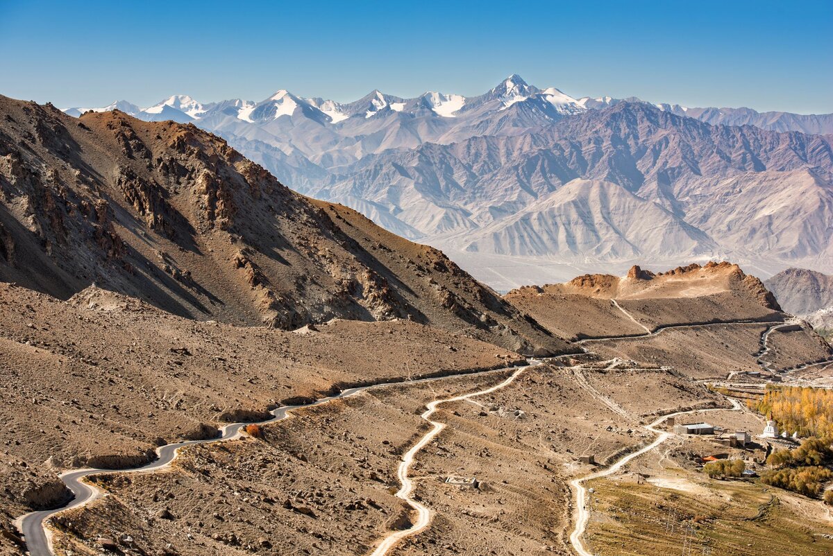
Over roughly 428 km of high-altitude highway, you pass from lush Himachali valleys into the cold desert of Ladakh. Forests fade into rock, then rock into sand and ice. The road threads between hanging glaciers, turquoise streams, and plateaus so high they feel like another planet.
But the real difference?
You don’t just see the Himalayas here—you feel them in your lungs, legs, and nerves. The air thins. Your vehicle struggles. Every pass is a small victory.
By the time you roll into Leh, prayer flags snapping above the road, the trip has quietly turned into a story about what you can endure and enjoy when you travel slowly and respectfully through serious mountains.
2. Route Overview: What Exactly Is This Highway?
The Leh–Manali Highway (NH 3) connects the town of Manali in Himachal Pradesh with Leh, the capital of Ladakh. It’s one of the world’s highest motorable highways, with long stretches above 4,000 m, and its highest point at Tanglang La pass (~5,328 m).
You’ll usually travel northbound:
- Start: Manali (~2,000 m)
- Through: Atal Tunnel – Sissu – Tandi – Keylong – Jispa – Darcha – Zingzingbar – Baralacha La – Sarchu – Gata Loops – Nakee La – Lachulung La – Pang – More Plains – Tanglang La – Gya – Upshi – Karu
- Finish: Leh (~3,500 m)
Most travelers now go via the Atal Tunnel, the 9.02 km engineering marvel that bypasses Rohtang Pass and cuts hours off the journey to Keylong.
Think of the route in three big stages:
- Manali to Jispa / Keylong – Green valleys, rivers, new tunnel, villages.
- Jispa to Sarchu – Glaciers, lakes, and your first serious high pass.
- Sarchu to Leh – High plateaus, hairpin bends, three big passes, and the entry to the Indus valley.
3. Best Time for a Manali to Leh Ladakh Road Trip
The highway is not an all-year road. Heavy winter snowfall closes the high passes for several months each year; the road typically reopens in late spring after extensive snow clearance by the Border Roads Organisation (BRO).
For most self-planned road trips, the sweet spot is:
- Early June to mid-July
- Snow walls still linger near passes.
- Roads can be slushy with meltwater; water crossings are stronger in the afternoon.
- Magical landscapes, but you need patience and warm gear.
- Snow walls still linger near passes.
- Mid-July to late August
- Longest daylight, relatively mild temperatures at high altitude.
- However, Himachal’s lower and mid-hills can see landslides and road blockages during heavy rain, which may disrupt approach to Manali or temporarily close sections of the highway.
- Longest daylight, relatively mild temperatures at high altitude.
- September to early October
- Crystal-clear skies, reduced traffic, golden-brown landscapes.
- Nights get very cold; water can freeze at Sarchu, Pang, and high passes.
- Early snowfall can shut upper sections without much warning.
- Crystal-clear skies, reduced traffic, golden-brown landscapes.
Outside these windows, the road is usually either closed or too risky for leisure travel. For an enjoyable Manali to Leh Ladakh road trip, aim for a 3–4 week broad window, not rigid dates, so you can adjust if the mountains decide otherwise.
4. How Many Days Do You Actually Need?
This is the question every traveler asks first.
Technically, with the Atal Tunnel and good weather, the drive can be done in one very long day of 14–16 hours. But ask yourself:
Do you want to survive the road, or actually experience it?
For most travelers, a 2- to 3-day journey from Manali to Leh is ideal.
- 2 days (fast but common)
- Day 1: Manali – Jispa / Sarchu
- Day 2: Jispa / Sarchu – Leh
- Works if you are short on time and in good health, but altitude gain is intense.
- 3 days (recommended)
- Day 1: Manali – Jispa/Keylong
- Day 2: Jispa – Sarchu/Pang
- Day 3: Sarchu/Pang – Leh
- More time for your body to adjust and for you to actually enjoy the views.
If you’re prone to altitude issues, traveling with children or older family members, or riding a motorcycle, three days is much kinder to your body.
5. Acclimatization & High-Altitude Safety
Before we dive into the dreamy bits, a reality check.
Much of the Manali to Leh Ladakh road trip is over 4,000 m. Acute Mountain Sickness (AMS) is common, and serious altitude illness can be fatal if ignored. Authorities in Ladakh explicitly advise at least 48 hours of acclimatization before going to even higher areas, and emphasize slow ascent, rest, and medical caution.
On this route, you don’t have the luxury of gradual, low-altitude travel. The road jumps from about 2,000 m in Manali to over 5,000 m at Tanglang La in just two or three days. That makes your choices matter.
Key principles to stay safe:
- Sleep low, climb high slowly
- First night: Jispa or Keylong (~3,100–3,200 m) is better than Sarchu for acclimatization.
- Sarchu (~4,200 m) is notorious for headaches, nausea, and breathlessness, especially for those coming straight from Manali.
- First night: Jispa or Keylong (~3,100–3,200 m) is better than Sarchu for acclimatization.
- Watch your body
- Mild headache, slight fatigue, and breathlessness are common.
- If you feel worsening headache, vomiting, confusion, severe fatigue, or breathlessness at rest, descend immediately; do not just “sleep it off.”
- Mild headache, slight fatigue, and breathlessness are common.
- Hydrate and fuel up
- Drink water regularly; cool, dry mountain air dehydrates you quickly.
- Eat light, frequent meals; avoid heavy, greasy food that makes you sluggish.
- Drink water regularly; cool, dry mountain air dehydrates you quickly.
- No alcohol, no smoking, no heroics
- Alcohol, smoking, and overexertion increase your risk of AMS.
- That “one drink to celebrate at Sarchu” might be what makes the rest of the night miserable.
- Alcohol, smoking, and overexertion increase your risk of AMS.
- Medical prep
- Talk to your doctor about high-altitude travel, especially if you have heart, lung, or blood-pressure issues.
- Medicines like acetazolamide (commonly used for altitude) should only be taken under medical guidance.
- Talk to your doctor about high-altitude travel, especially if you have heart, lung, or blood-pressure issues.
Local police and media regularly report altitude-related emergencies, including deaths, on this highway—especially around Darcha, Sarchu, and the high passes. Treat the mountains with respect, and they reward you with memories rather than hospital visits.
6. Manali: Your Launch Pad into the High Himalayas
Spend at least one full day in Manali before starting the drive. It’s not just about sightseeing; it’s about getting organized.
6.1 Getting Your Paperwork & Permits
For a Manali to Leh Ladakh road trip via the Atal Tunnel, you generally need:
- Basic ID proof – Aadhaar, driving license, passport, etc.
- Vehicle documents – Registration, insurance, Pollution Under Control certificate.
If you plan to detour to Rohtang Pass itself (rather than just using the Atal Tunnel), a permit and environmental fee are usually required for vehicles heading from Manali toward Rohtang. These can be applied for online through the state’s permit portal.
For the main highway via the Atal Tunnel, travelers typically do not need the Rohtang tourist permit—but regulations can change, so always verify with the official permit website or local tourism office before you go.
If your Ladakh plan includes Nubra Valley, Pangong Lake, Tso Moriri, or other border areas, you will need Inner Line Permits (ILP) for Indian nationals or Protected Area Permits (PAP) for foreign nationals, issued by the Ladakh administration in Leh or through its online portal.
6.2 Last-Minute Prep in Manali
Manali is your last big town before the landscape gets serious. Use it well.
- Check your vehicle: brakes, coolant, engine oil, tyres (including spare), lights, and horn.
- Buy snacks, nuts, energy bars, and instant foods that you know sit well with your stomach.
- Rent or buy cold-weather gear, especially if you’re traveling early or late in the season.
- Sort out cash; ATMs thin out rapidly beyond Manali, and card machines are unreliable in remote areas.
Sleep early. Your first day starts long before the sun comes up.
7. Day 1: Manali to Jispa / Keylong – From Pine Forests to the Lahaul Valley
Approx distance: ~130–140 km (via Atal Tunnel)
Driving time: 4–6 hours, depending on stops and road conditions
You leave Manali in the dark, headlights brushing the Beas River. As you climb toward Solang and Palchan, the forest closes in, and the air sharpens.
Soon the road swings toward the Atal Tunnel, its massive portal glowing in the half-light. Inside, for nine kilometers, the world shrinks to concrete walls and the echo of engines. When you burst out of the north portal, it’s like changing countries. Forested slopes give way to Lahaul’s wide, open valley, with the Chandra River carving a silver ribbon through brown mountains.
7.1 Sissu: First Taste of the “Other Side”
Your first major halt is often Sissu, a pretty village with waterfalls cascading down bare cliffs and apple orchards tucked into sheltered pockets. It’s a great place to:
- Grab breakfast at a roadside dhaba.
- Take a short walk along the river to stretch your legs.
- Feel the difference: the air here already has that dry, cold edge that will follow you all the way to Leh.
7.2 Tandi: Where Two Rivers Meet (and the Last Sure Fuel)
A little ahead lies Tandi, where the Chandra and Bhaga rivers merge to form the Chandrabhaga (later known as the Chenab). There’s usually a clear sign proclaiming the confluence; many travelers stop here for photos and a brief pause.
More importantly for you:
- Tandi is a crucial fuel station. Traditionally, this is treated as the last guaranteed petrol pump before Leh, although small outlets sometimes operate further along in seasons.
- Even if your tank is nearly full, top up completely here. If you’re on a motorcycle or a car with a smaller tank and expect to detour around, carry extra fuel in proper jerry cans.
7.3 Keylong & Jispa: Where to Spend the Night
From Tandi, the road climbs gently along the Bhaga River toward Keylong, the district headquarters of Lahaul and Spiti. It’s a small town with monasteries perched above the valley, a market, and some modest hotels and guesthouses.
Another hour brings you to Jispa, a quieter village right on the river, surrounded by high peaks and fields. Jispa has become a favorite night halt because:
- It’s high enough (~3,100+ m) for your body to start adjusting, but not brutally high.
- There are cozy guesthouses, riverside camps, and homestays with hearty food and warm conversations.
- You can walk down to the river in the evening, watch prayer flags flutter against a sky heavy with stars, and let your mind settle into the journey.

For many travelers, waking up in Jispa feels like the true start of Ladakh—even though you’re still in Himachal.
8. Day 2: Jispa to Sarchu / Pang – Into the High Passes
Approx distance (Jispa–Sarchu–Pang): ~160–180 km
Driving time: 6–8+ hours, with frequent photo and rest stops
This is a day of altitude and adrenaline. You’re entering serious high country now.
8.1 Darcha & Beyond: End of the Treeline
Soon after Jispa comes Darcha, a small settlement that acts as a gateway for treks to Zanskar and beyond. You’ll usually cross a police check-post here; keep your IDs handy.
Past Darcha, the greenery bleeds away. Trees shrink and vanish. The road clings to slopes etched with dried waterfalls, and the river narrows into frothing rapids.
8.2 Deepak Tal & Zingzingbar: Lakes, Streams, and Cold Winds
You skirt Deepak Tal, a compact, glassy lake often ringed with prayer flags. On calm days it mirrors the peaks; on windy days it ruffles into steel-gray ripples.

Further on is Zingzingbar, a classic high-altitude halt: a scattering of dhabas, tents, and trucks with snow peaks looming above. Here you feel the wind’s bite more sharply, and the first hints of dizziness remind you you’re climbing fast.
8.3 Baralacha La & Suraj Tal: Where the Road Meets the Sky
The climb to Baralacha La is long and mesmerizing. The mountains here wear glaciers like shawls; streams from melting ice cross the road in sparkling torrents. In early season, these “nallahs” can be deep by afternoon, so starting your day early really matters.
At the top, the world flattens briefly. Baralacha La sits at over 4,800 m, often wrapped in wind and wisps of cloud. The air is thin, the silence almost complete.
Just before or after the pass (depending on your direction), you see Suraj Tal, a surreal blue-green lake cupped in a bowl of rock and snow. Photographs don’t quite capture how otherworldly this stretch feels.
Take it slow here: step out, walk a little, breathe calmly, and listen to your body.
8.4 Bharatpur to Sarchu: High Plateau and Borderlines
Descending from Baralacha La, you pass Bharatpur, a seasonal cluster of camps and dhabas where hot parathas and chai taste better than any city restaurant.
Soon after, you cross a bridge and roll into the broad valley of Sarchu, which marks the border between Himachal Pradesh and Ladakh. Sarchu lies on a vast, high-altitude plain, with tented camps and a wind that never seems to stop.
Sarchu is a popular overnight halt, especially for travelers doing the trip in two days. But it’s also high—around 4,200 m. If you choose to sleep here:
- Avoid heavy dinners; eat light and early.
- Stay warm, keep your head and feet covered.
- Expect a restless night; many people feel breathless lying down.
If you’re traveling with family, older travelers, or if you already feel the strain of altitude, consider pushing on to Pang or staying lower in Jispa instead and doing a longer drive the next day.
9. Day 3: Sarchu / Pang to Leh – Gata Loops, Moon Landscapes, and the Indus
Approx distance (Sarchu–Leh): ~250 km
Driving time: 8–10 hours
This is the day that usually turns the Manali to Leh Ladakh road trip into a story people tell for years.
9.1 Gata Loops & Nakee La: The Hairpin Staircase
Leaving Sarchu, you soon hit the legendary Gata Loops—a series of more than 20 hairpin bends stacked on top of each other. From above, the road looks like someone has scribbled zigzags into the mountain.

You climb steadily, engine humming, drop after drop falling away beneath you. It’s spectacular, but if you’re prone to motion sickness, this section can test you.
At the top of the loops lies Nakee La, a high, wind-scoured pass with incredible views and often colorful signboards put up by the BRO.
9.2 Lachulung La & Pang: Jagged Peaks and Wind-Cut Canyons
Between Nakee La and Lachulung La, the mountains become a geological playground. Rock walls crumble into hoodoos and fins, shaped by centuries of freeze and thaw. The colors shift from deep rust to beige to almost purple in places.
Lachulung La is another high pass, again over 4,800 m. The air here can feel razor-thin. Don’t linger too long; short walks, some deep breaths, and then roll downhill toward Pang.

Pang is a cluster of parachute tents at about 4,600 m, nestled beside a dramatic gorge. It’s a common tea and lunch stop, and some travelers camp here if doing the journey more slowly.
9.3 More Plains: Driving Across the Sky
After Pang, the road suddenly straightens and the world opens into the More Plains, a 40 km-long, almost flat plateau at roughly 4,700 m.
This is where drivers often feel a strange urge to speed. The tarmac stretches ahead like a runway, flanked by distant peaks and occasional herds of kiang (wild asses) or yaks.
Resist the temptation to go too fast. The altitude is still punishing, and sudden dips, gravel patches, or animal crossings can surprise you. Roll your windows down, let the thin, cold wind in, and soak in the feeling of driving so high that the clouds look almost level with your eyes.
9.4 Tanglang La: The Final High Pass
At the far end of the plains begins your final major climb to Tanglang La, often cited as one of the highest motorable passes in the world at around 5,328 m.
The climb is steady, zigzagging up barren slopes. At the top, prayer flags snap in the wind, and signboards celebrate the engineering feat of bringing a road here at all. Most travelers feel a mix of awe and relief; after Tanglang La, everything slowly starts going down.
9.5 Down to Leh: First Glimpse of the Indus
Descending from Tanglang La, the landscape softens into villages, barley fields, and stupas. You pass Gya, Rumtse, and eventually reach Upshi, where the road meets the Indus River for the first time on this journey.
From Upshi to Leh via Karu, the valley widens, dotted with monasteries perched on crags and tiny hamlets clinging to the riverbanks. Traffic increases. Prayer wheels appear beside the road.
And then, sometime in the fading light, you see it:
LEH – a cluster of whitewashed houses, a palace on a ridge, and above it all, a line of snow peaks catching the last light.
You’ve made it.
10. Vehicle Choices: Car, Bike, Bus, or Taxi?
The romance of the Manali to Leh Ladakh road trip is often tied to motorcycles, but there are several ways to do this journey. Each has its own texture.
10.1 Motorcycle
Riding a bike through this landscape is pure immersion: you feel every gust of wind, every drop in temperature, each change in smell and sound.
If you choose to ride:
- Prefer bikes 350 cc and above for better torque and load-carrying capacity.
- Carry basic spares: clutch/throttle cables, fuses, tubes or puncture repair kits, spark plug, chain lube.
- Protect yourself with good riding gear: full-face helmet, riding jacket with armor, waterproof gloves, knee guards, and boots that cover your ankles.
- Try to keep your luggage to a minimum; overloading the bike stresses both engine and rider.
10.2 Self-Drive Car
A car offers shelter from wind and cold, plus space for family or friends.
- SUVs with decent ground clearance are strongly preferred, though many travelers successfully do the trip in compact SUVs and well-driven hatchbacks.
- A 4×4 is helpful in early season or after fresh snowfall but not mandatory in peak summer if roads are clear.
- Learn to use engine braking on long descents; riding your brakes can overheat them.
- On water crossings, pause for a minute, watch another vehicle cross, pick the shallowest line, and go through steadily without stopping.
10.3 Taxi or Shared Cab
If you don’t want the stress of driving at altitude, taxis from Manali and shared cabs are widely available in season. They are faster, as local drivers know the road intimately, but you sacrifice some flexibility.
10.4 Government Buses
Himachal Road Transport Corporation (HRTC) and Himachal Pradesh Tourism Development Corporation (HPTDC) usually run 2-day buses between Manali and Leh, with a night halt at Keylong or Sarchu.
Bus travel is slower and more crowded, but also cheaper. If you want to see the road without worrying about driving, this can be a surprisingly memorable way to travel—especially if you enjoy sharing space with locals.
11. Fuel, Food, and Stay: The Practical Stuff That Makes or Breaks Your Trip
11.1 Fuel Planning
Typical fuel points on or near the route include:
- Manali – Multiple fuel stations.
- Tandi – Crucial refueling point; traditionally the last major pump before Leh.
- Karu (near Leh) – Fuel station before the city, convenient for onward journeys.
Seasonally, smaller outlets may operate in places like Keylong or Jispa, but they can’t always be relied on. Treat your fuel strategy as if Tandi to Leh is one long stretch without guaranteed fuel.
11.2 Food & Water
You’ll find dhabas and small eateries at:
- Solang / Palchan area
- Sissu, Tandi, Keylong, Jispa
- Darcha, Zingzingbar
- Bharatpur, Sarchu
- Pang
- Villages after Rumtse toward Leh
Food is usually simple: rice, dal, sabzi, Maggi, parathas, momos, omelettes. It’s not gourmet, but after a few hours on the road, a hot plate of dal-chawal at 4,500 m tastes like luxury.
Water:
- Carry at least 2–3 liters per person per day.
- Use reusable bottles; refill at guesthouses or safe taps instead of buying endless plastic bottles.
- Avoid drinking directly from streams unless you treat or boil the water.
11.3 Accommodation Along the Route
Depending on the season, you can find a mix of:
- Hotels and guesthouses – Manali, Keylong, Jispa, Leh.
- Homestays – Increasingly common in Lahaul and Ladakh villages.
- Fixed camps / tented accommodation – Sarchu, Bharatpur, Pang (in season).
Book the first night (Manali and Jispa/Keylong) in advance during peak months; mid-route camps often take walk-ins but can fill up quickly when traffic is heavy.
12. Packing for the Manali to Leh Ladakh Road Trip
Think of your packing in layers: weather, altitude, and isolation.
12.1 Clothing
- Base layers: Thermal innerwear for nights and higher passes.
- Insulating layers: Fleece or light down jacket.
- Outer shell: Waterproof and windproof jacket; rain pants if riding.
- Accessories: Warm cap, buff or scarf, sunglasses with UV protection, warm socks, lightweight gloves plus insulated gloves if on a bike.
Dress in layers so you can adapt quickly when the sun ducks behind a cloud or when you climb from a sunny valley to a snowy pass.
12.2 Health & Safety
- Personal medicines plus: basic painkillers, anti-nausea tablets, rehydration salts, bandages, antiseptic cream.
- High-SPF sunscreen and lip balm (the sun at altitude is fierce).
- Small first-aid kit that someone in your group knows how to use.
- Reusable hot water bag if you feel the cold strongly.
12.3 Gear & Miscellaneous
- Power bank and charging cables – There may be long stretches without reliable electricity.
- Offline maps pre-downloaded on your phone; mobile signal drops out for much of the highway.
- Headlamp or small torch.
- Light snacks and energy bars.
- Spare vehicle key, kept separate from the main one.
13. Beyond Leh: Extending Your Road Trip
Your Manali to Leh Ladakh road trip doesn’t have to stop at Leh. Once you’ve rested and acclimatized properly, you can branch out to:
- Nubra Valley – Sand dunes, double-humped camels, monasteries, and views of the Karakoram.
- Pangong Lake – The shifting blue icon you’ve probably seen in a hundred photos.
- Tso Moriri & Tso Kar – High-altitude lakes with fewer crowds and nesting birds in season.
- Zanskar via the Nimmu–Padum–Darcha road – A newer route linking Ladakh and Himachal through dramatic, less-traveled valleys.
Remember: most of these areas require permits and further acclimatization. Give yourself time.
14. Responsible Travel in Fragile High-Altitude Landscapes
The beauty you’ve come to see is also extremely fragile. Cold deserts recover slowly from damage; a plastic bottle or tyre scars can linger for years. Local administrations and tourism departments actively urge visitors to minimize their impact and respect cultural norms.
As you drive this legendary highway:
- Carry your trash back to larger towns; don’t dump it behind dhabas or by the roadside.
- Avoid single-use plastic as much as you can; refill bottles instead of buying new ones.
- Stick to existing tracks; off-roading tears up fragile soil and vegetation.
- Keep noise low near villages, monasteries, and camps; not everyone wants your favorite playlist at full volume.
- Dress modestly in villages and religious places; ask before photographing people.
Responsible travel is not a buzzword here. It’s what keeps this route magical for those who come after you.
15. Frequently Asked Questions
Q1. Is the Manali to Leh Ladakh road trip suitable for first-time mountain drivers?
It can be, but only if you’re confident, cautious, and patient. Start driving in hills on easier roads first. On this highway, avoid driving at night, don’t overtake blindly, and respect trucks and locals who know the road better than you.
Q2. Can children or older travelers do this trip?
Yes, many families do. But altitude affects everyone differently. Plan more days, sleep lower when possible (Jispa instead of Sarchu on the first night), keep a close eye on symptoms, and consult a doctor before traveling with very young children or anyone with heart/lung conditions.
Q3. Is it better to go from Srinagar to Leh first and then Leh to Manali?
Some travelers prefer approaching Ladakh from the Srinagar–Leh side, which offers a more gradual altitude gain and then returning via Leh–Manali. If you have enough time, this “loop” often feels easier on the body and richer in experiences.
Q4. Do I need to book everything in advance?
Book your stays in Manali, Jispa/Keylong, and Leh in advance during peak months. Mid-route camps (Sarchu, Pang, Bharatpur) often work well with same-day decisions, but if you’re very particular about comfort, pre-booking is safer.
Q5. Is network and internet available on the highway?
Expect long stretches with no mobile signal at all, particularly between Darcha and Upshi. Some villages and camps offer patchy connectivity, but it’s best to assume you’ll be mostly offline on driving days.
16. The Road That Stays With You
When you finally park in Leh and switch off the ignition, there’s a moment of ringing silence. No engine, no wind buffeting the windows, no endless bends demanding your attention. Just stillness and thin, bright air.
Over the next days, as you wander around Leh’s markets or climb up to Shanti Stupa, your mind keeps returning to the road: the first glimpse of snow near Baralacha La, the surreal vastness of More Plains, the dizzying switchbacks of Gata Loops.
A Manali to Leh Ladakh road trip isn’t just another scenic drive. It’s a slow negotiation with altitude, weather, and your own limits. It teaches you to start early, travel lightly, listen carefully—to the road, your body, and the mountains themselves.
When you leave Ladakh, it’s hard not to glance south and think:
One day, I’m going to drive that road again.
References
Leh–Manali Highway
Leh–Manali Highway – National Highway 3 https://en.wikipedia.org/wiki/Leh%E2%80%93Manali_Highway
Atal Tunnel
Atal Tunnel – Wikipedia https://en.wikipedia.org/wiki/Atal_Tunnel
Atal Tunnel – Official BRO Portal https://marvels.bro.gov.in/AtalTunnel
Border Roads Organisation & Government Releases
PIB Release on Leh–Manali Highway https://pib.gov.in/PressReleseDetailm.aspx?PRID=1910802
Manali–Leh Link Reopens – Times of India https://timesofindia.indiatimes.com/city/shimla/manali-leh-link-reopens-after-46-day-clearup/articleshow/121147206.cms
Road Status & Travel Advisories — Lahaul–Spiti & Manali–Leh
Lahaul–Spiti District Road Status https://hplahaulspiti.nic.in/road-status/
Best Time to Visit Leh–Ladakh
Best Time to Visit – Leh Ladakh Tourism https://www.lehladakhtourism.com/best-time-to-visit-leh-ladakh/
Best Time to Visit – LehLadakhIndia https://www.lehladakhindia.com/best-time-to-visit-leh-ladakh/
Climate & Weather Guide – Leh Ladakh Taxi https://www.lehladakhtaxis.com/practical-info/best-time-to-visit-ladakh-climate-weather
Inner Line & Protected Area Permits
Leh District Permit Tracking System https://www.lahdclehpermit.in/
Protected Area Permit – Leh District https://leh.nic.in/requiring-protected-area-permit/
Inner Line Permit Guide – Leh Ladakh Taxi https://www.lehladakhtaxis.com/practical-info/inner-line-permit-for-ladakh
High-Altitude Health & Acclimatization
Health Advisory – Leh District Permit Portal https://www.lahdclehpermit.in/healthadvisory
Indian Adventure Tourism Guidelines (PDF) https://tourism.gov.in/sites/default/files/2019-10/Indian%20Adventure%20Tourism%20Guidelines%20Oct%202.pdf
Acclimatization Guide – LehLadakhIndia https://www.lehladakhindia.com/acclimatization/
Rohtang Pass & Permit System
Official Rohtang Pass Permit Portal https://rohtangpermits.nic.in/
Rohtang Pass Permit Info – Discover with Dheeraj https://discoverwithdheeraj.com/rohtang-pass-permit-mobile-app-updates-2021-22/
Manali–Leh Route & Altitude Points
Manali to Ladakh Route – eUttaranchal https://www.euttaranchal.com/tourism/manali-to-ladakh-route.php
High Himalayan Passes – Tripoto https://www.tripoto.com/trip/5-high-altitude-himalayan-passes-of-manali-leh-highway-5c1f84204f027
Weather Extremes & Seasonal Road Closures
Heavy Snowfall in HP – TOI https://timesofindia.indiatimes.com/city/chandigarh/hp-experiences-heavy-snowfall-rain-for-3rd-consecutive-day/articleshow/124365364.cms
Fresh Snowfall Blocks Roads – TOI https://timesofindia.indiatimes.com/city/chandigarh/fresh-snowfall-blocks-roads-lowers-temperatures-in-hp/articleshow/125114188.cms
Manali–Leh Highway Blocked – TOI https://timesofindia.indiatimes.com/city/chandigarh/manali-leh-highway-blocked-as-snowfall-rain-hit-hp/articleshow/124342443.cms
Altitude-Related Incidents & Safety
High-Altitude Sickness Incident – TOI https://timesofindia.indiatimes.com/city/chandigarh/punjab-tourist-dies-due-to-high-altitude-sickness-on-manali-leh-highway/articleshow/121578680.cms
Tourism & Environmental Guidelines
Tourist & Environmental Guidelines (PDF) https://cdnbbsr.s3waas.gov.in/s395192c98732387165bf8e396c0f2dad2/uploads/2024/10/20241022345282423.pdf