Great River Road Itinerary ( Minnesota to Louisiana ) — 3,000-Mile Road-Trip Planner & Must-See Stops for 2025-26
Dreaming of tracing the entire Mississippi River on one unforgettable Minnesota to Louisiana road trip along the Great River Road? Picture beginning at Lake Itasca’s ankle-deep headwaters, rolling past cedar-scented bluffs and bald-eagle lookouts, and ending where Spanish moss drapes over Louisiana bayous.
This signature American drive strings together ten states, 3,000 miles of winding asphalt, and hundreds of river towns—each ready with its brewpub, blues club, or hiking trail. Whether you have a weekend to sample a single stretch or two weeks to follow the iconic pilot-wheel signs to the Gulf, the Great River Road rewards every curious traveler with constant views and zero interstate monotony.
Ready to map out fuel stops, must-see detours, and the comfiest river-view lodgings? Let’s start planning the perfect headwaters-to-delta adventure.
Table of Contents
Why plan this drive now?
Have you ever wanted to follow the entire Mississippi from its first ankle-deep trickle to its tidal finale in the Gulf? The Great River Road (GRR) strings together ten states, two time zones, and the stories of America’s most fabled waterway. From Lake Itasca’s pine-scented quiet to Louisiana’s live-oak canopies, you’ll roll past 3,000 miles of bluff-top overlooks, wildlife refuges, river towns, and big-city skylines.
Trip-Planning Essentials
Route & signage. The GRR isn’t one continuous highway; it’s a mosaic of state, U.S., and county roads. Watch for the white sign with the green pilot’s-wheel logo—the symbol appears anywhere the official route shifts.
Distance & timing. You can drive the length in roughly 36 hours, but most travelers spend 10–14 days if they want to linger at museums, wineries, and wildlife sanctuaries.
Best seasons. Spring (April–June) and fall (September–October) balance mild temperatures with wild-flower blooms or fiery foliage. Summer brings longer daylight and foodie festivals; winter offers uncrowded eagle-watching but requires snow-ready tires up north.
Navigation tip. Cell coverage is reliable on the whole, yet rural bluffs can create dead zones. Pre-download state DOT offline maps and keep a printed GRR map as backup.
Budget snapshot. Fuel for a mid-size SUV over 3,000 miles averages US$450–$550 at July 2025 prices. Lodging spans $15 primitive campsites to $400 river-view suites; most readers report spending $140–$190 per night for mid-range rooms.
Great River Road: Route Guide — State-by-State Highlights (Miles 0 – 3,000)
MINNESOTA – Headwaters to Hastings (Miles 0-340)
Lake Itasca to Bemidji: Stand on stepping-stones across the trickle where the Mississippi is born in Itasca State Park, then bike the 16-mile Wilderness Drive loop for quiet loon calls at dusk. Visitor centers are open daily 10 a.m.–8 p.m.; buy a $7 day pass at the Mary Gibbs Headwaters Center.
Brainerd Lakes & Cuyuna Country: Southbound, swap pavement for the red-cedar-scented Cuyuna Lakes Mountain Bike Trails—45 miles of purpose-built single-track in an old mine pit landscape turned aqua-blue lakes. Post-ride, cast for walleye off the Brainerd pier at sunset.
Little Falls to St. Cloud: Do you love quirky roadside art? Pull into Little Falls for Charles Lindbergh’s childhood home, then picnic among the tulips of Munsinger Gardens along the St. Cloud riverfront.
Twin Cities river gorge: Minneapolis and St. Paul offer miles of riverfront greenway. Join local cyclists on West River Parkway, tour the Mill City Museum inside a 19th-century flour mill, and grab Nordic-style coffee in the St. Anthony Falls area before hugging the bluffs toward historic Hastings.
Practical tip. Weekends overflow with local 5 Ks and farmers’ markets—arrive before 9 a.m. to find free riverside parking.
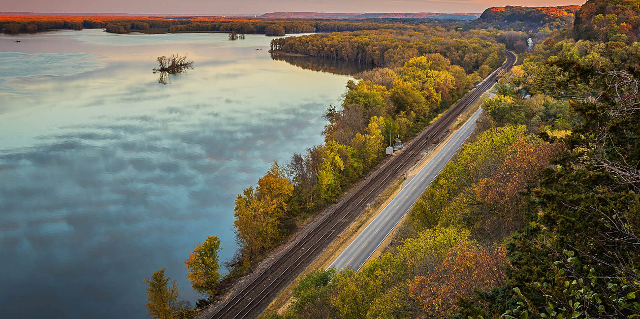
WISCONSIN – Bluffs, Wine Trails & Eagle-Watching (Miles 340-640)
Prescott to Stockholm: Crossing the Highway 61 bridge, you enter a 250-mile ribbon of limestone palisades, art villages, and vineyards. Quaint Stockholm’s pie bakeries sit opposite Lake Pepin’s sailboats—have you tasted rhubarb pie right on the dock?
Pepin & Alma: Trace Laura Ingalls Wilder’s footsteps at Laura Days in Pepin (Sept 13–14, 2025) or sip Frontenac rosé on Villa Bellezza’s piazza during the Summer Cookout Wine Trail (July 11–13).
Trempealeau National Wildlife Refuge: Binoculars ready? Autumn migrations bring clouds of tundra swans and pelicans; follow the auto-loop at golden hour.
La Crosse to Prairie du Chien: Hike Grandad Bluff for a balcony-view sunset, then drive scenic Highway 35, detouring for smoked gouda at the Alma Cheese Factory. Prairie du Chien—Wisconsin’s second-oldest community—hosts Friday night riverfront concerts all summer.
Travel logistics: Many overlooks close by 10 p.m.; plan night photography early. Cyclists should carry flashing taillights—shoulders narrow south of Lynxville.
IOWA – Clifftop Vistas & River Lore (Miles 640-940)
Effigy Mounds National Monument: Stretch your legs on the 3-mile Fire Point loop; 31 prehistoric animal-shaped mounds emerge from oak ridges. Visitor center hours vary (closed Tue-Wed until May 2026), so download trail maps ahead.
Dubuque: Two can’t-miss stops: the National Mississippi River Museum & Aquarium—check out the new “Water’s Extreme Journey” maze (through March 2025) and upcoming live-animal galleries—and the Fenelon Place elevator, the world’s shortest, steepest railway.
Guttenberg & Pikes Peak: Just south, Pikes Peak State Park’s 500-foot bluff deck frames barges gliding around hairpin bends. Stay late for Milky Way photos; the park is an Iowa Dark-Sky gem.
Muscatine & Lock 16: Long before GPS, local engineer Charles Young designed the GRR pilot-wheel sign; visit Muscatine’s riverfront interpretive panels to learn how the signage was born.
Practical tip. Check the spring flood outlook (issued each March) before traveling; minor detours can add an hour.
ILLINOIS & MISSOURI – Limestone Bluffs to Gateway Arch (Miles 940-1,375)
Savanna to Galena: Illinois’ northwest corner pairs eagles, antiques, and Ulysses S. Grant’s Italianate home. Stay in an 1850s B&B and walk Galena’s brick Main Street after day trippers leave.
Quad Cities to Nauvoo: Want a small-town festival? Try LeClaire’s Tug Fest in August: Illinois and Iowa literally play tug-of-war across the river. Continue past Nauvoo’s 1840s temple ridge for sweeping dusk views.
Great Rivers Scenic Route (Alton, IL): Drive the 25-mile stretch where peregrine falcons cruise limestone cliffs and winter bald-eagle counts break records—stop at the Piasa Bird mural pull-out for photos.
St. Louis: Park along the freshly reconnected riverfront and ride the tram 630 feet inside the Gateway Arch for a glass-wall panorama. Brand-new Chain of Rocks Park opened in 2024, transforming the historic Route 66 bridge into a pedestrian garden link.
Bootheel blues: Follow Highway 61 south of Cape Girardeau for Delta cultural stops and barbecue smokehouses before crossing into Kentucky.
KENTUCKY & TENNESSEE – Ancient Mounds & Shimmering Lakes (Miles 1,375-1,550)
Wickliffe Mounds, KY: This riverside state park preserves Mississippian earthworks; the museum’s elevated boardwalk keeps you eye-level with 800-year-old village life. Columbus-Belmont State Park offers shaded campsites 30 minutes away.
Reelfoot Lake, TN: A 15,000-acre earthquake-born cypress lake; rent a kayak at Tiptonville for ethereal sunrise mist and osprey chatter. Birders flock here January–March for bald-eagle tours.
Memphis detour: Craving live blues? Beale Street’s patios ignite nightly just five blocks off the GRR; allow half a day for the riverfront Tom Lee Park & National Civil Rights Museum.
ARKANSAS – Bayous, Bike Rails & Delta Heritage (Miles 1,550-1,900)
Helena-West Helena: Start at the Delta Cultural Center’s interactive blues studio, then climb Crowley’s Ridge Drive for craning views over soybean flats.
Delta Heritage Trail State Park: Pedal a rail-trail from Barton to Lake View, then swap wheels for a kayak on Old Town Lake via the park’s Pedal-&-Paddle tour—ideal for families wanting a guided half-day.
Lake Chicot State Park: America’s largest oxbow lake curves like a crescent moon at the state line; sunset paddles here rival anything in the Everglades.
MISSISSIPPI – Civil War Echoes & River Casinos (Miles 1,900-2,350)
Vicksburg: Tour the Lower Mississippi River Museum, kayak catfish-rich backwaters at sunset, then dine at 10 South Rooftop for Delta shrimp over river glints.
Natchez Trace tie-in: The GRR intersects the Natchez Trace Parkway at milepost 0—consider a 10-mile bike out-and-back to cypress-lined Emerald Mound for sunrise.
Port Gibson & Windsor Ruins: Locals claim U.S. Grant spared Port Gibson because it was “too beautiful to burn.” Stroll live-oak-arched Church Street, then snap Windsor’s ghostly Corinthian columns in golden light.
Practical tip. Casinos south of Vicksburg offer all-night diesel; gas stations in rural Claiborne County close by 9 p.m.
LOUISIANA – Plantations, Swamps & Gulf Breeze (Miles 2,350-3,000)
Baton Rouge: Capitol views from the 34-story observation deck stretch 30 miles; history buffs can tour the art-deco Old Governor’s Mansion before a po-boy lunch at Poor Boy Lloyd’s.
River Road Plantations: Within the 70-mile corridor between Baton Rouge and New Orleans, visit Houmas House’s lush gardens and the Great River Road Museum’s 35,000-sq-ft steamboat-shaped galleries, then pair Oak Alley’s colonnaded oaks with Whitney Plantation’s slavery narratives for a balanced view of history.
Swamp detour: Book a Cajun Encounters flat-bottom boat tour at Honey Island Swamp—expect gator sightings year-round.
New Orleans finale: Drive atop the levee into Algiers Point for a photo of the downtown skyline reflected in the river’s final bends, then celebrate with beignets in the French Quarter.
Practical tip. Traffic on I-10 between Kenner and downtown thickens 3 p.m.–6 p.m.; aim for midday or take LA-18/LA-3127 on the west bank to bypass congestion.
Responsible & Safe Travel
Drive the posted speeds—wildlife crossings spike at dawn and dusk. Check daily NOAA river gauges in spring; water can cover low roads near locks. Pack refillable bottles: most interpretive centers provide filtered stations. Finally, remember the Mississippi drains 41 percent of the continental U.S.—anything you drop on the roadside can wash to the Gulf.
Ready to roll?
Will you savor every detour or chase a southbound sprint? However you design your Minnesota-to-Louisiana odyssey, the Great River Road rewards curiosity at every meander. Grab your map, cue up river blues, and let the pilot-wheel signs guide you toward your own Mississippi story.
References
- Great River Road of Minnesota (mnmississippiriver.com) Great River Road of Minnesota
- Explore Minnesota — Itasca State Park hours & passes MN DNR
- National Mississippi River Museum & Aquarium exhibit releases Mississippi River Museum
- Discover Wisconsin — “10 Towns You Need to Tour” Discover Wisconsin
- Travel Wisconsin — Great River Road overview TravelWisconsin
- Travel Iowa — Great River Road National Scenic Byway Travel Iowa
- NPS — Effigy Mounds National Monument visitor info National Park Service
- Great Rivers Scenic Route (Explore St. Louis) Explore St. Louis
- Great Rivers Greenway — Chain of Rocks Park opening Great Rivers Greenway
- National Scenic Byway Foundation — Great River Road (KY, AR, TN) entries NSB FoundationNSB FoundationNSB Foundation
- Arkansas.com — Great River Road Delta article- Arkansas
- Delta Heritage Trail State Park – Pedal & Paddle tour Arkansas State Parks
- Visit Vicksburg scenic-drive guide Visit Vicksburg
- Southern Living — “18 Best Things to Do in Vicksburg” Southern Living
- Experience Mississippi River — Pilot-wheel signage & best-drive info Experience Mississippi River
- Adventure Life — Best season to travel the Mississippi Adventure Life
- Drive Weather App — GRR summary stats Drive Weather
- Explore Louisiana — River Road plantations guide Explore Louisiana
- Great River Road Museum interpretive center details Experience Mississippi River
- Daily Telegraph — Plantation tour reflections Daily Telegraph